Street Atlas USA 2005 User Guide
126
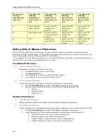
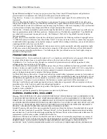
If you select to
view large
symbols at data
zoom level...
You will see the
following
information at
data zoom level
13-0
You will see the
following
information at
data zoom level
14-0
You will see the
following
information at
data zoom level
15-0
You will see the
following
information at
data zoom level
16-0
14
names and small
square symbols
name of the POI
and the large
symbol
name of the POI
and the large
symbol
name of the POI
and the large
symbol
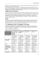
15
small squares only
name of the POI
and a small square
symbol
name of the POI
and the large
symbol
name of the POI
and the large
symbol
16
N/A
small square
symbols only
name of the POI
and a small square
symbol
name of the POI
and the large
symbol
Setting Units of Measure Preferences
Street Atlas USA 2005 allows you to change the units of measure used to represent how coordinate formats,
distance, and bearing listings display. Changing these preferences affects how units of measure display in several
areas of the program: such as on the map and in the Control Panel.
As you change your Unit of Measure preferences, a description of each choice displays in the information box (to
the left of the Overview Map) immediately after it is selected.
Coordinate Preferences
•
About Coordinate Preferences
Changing the coordinate preferences affects the:
Coordinates display on the Control Panel.
Coordinate MapNotes.
Grid label display, if Grids are selected in Map Features.
Any other place where coordinates display or print.
•
To Set Coordinate Preferences
Use the following steps to change how coordinate measurement units display.
1.
Click the
Map Display
tab and then click
Units
to display the Units options.
2.
Select the desired coordinate display format from the
Coords
drop-down list.
Degrees
Degrees, Minutes
Deg, Min, Sec
Distance Preferences
•
About Distance Preferences
Distance preferences affect how distance and areas display throughout the program.
•
To Set Distance Preferences
Use the following steps to change the measurement units for distance and area in Street Atlas USA 2005.
1.
Click the
Map Display
tab and then click
Units
to display the Units options.
2.
Under Measures, select the desired measurement from the Measures drop-down list.
•
Statute Miles (statute feet are used for small distances)
•
Kilometers (Meters are used for small distances)
•
Nautical Miles/Feet (statute feet are used for small distances)
•
Nautical Miles/Meters (meters are used for small distances)

