Street Atlas USA 2005 User Guide
124
•
Click the small
All
button to the right of the Search Results window to display all of the POI types
listed.
•
Click
Only
to display only those POI types listed in the Search Results window.
•
Click
Exclude
to display all POI types except those listed in the Search Results window.
4.
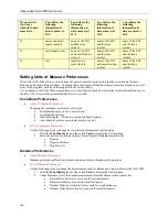
To use the map feature tree to select which features display on the map, click the plus signs to expand the
individual branches. A check mark indicates the POI type displays on the map.
Note
: Some branches expand further than others. Selecting/clearing a check box at a certain branch of the
tree shows/hides all the items below that level.
•
Select/clear the individual POI check box to show or hide that POI.
•
Click
All
to select all POIs in the program.
•
Click
None
to select none of the types in the program.
Note
: A small number of POIs cannot be turned off. They are part of the base map display and
cannot be changed. This explains why certain levels on the tree remain unavailable (appear
dimmed or gray).
5.
When you are finished editing the custom POIs, click
Done
. Your map view updates, displaying only those
POIs you have selected.
When you save the current Map File, the following map feature preferences are saved in reference to map
features:
•
(Major) map features preferences.
•
Individual custom POI preferences.
•
The choice to use basic map feature or custom POI preferences for that Map File.
Map Feature Option Descriptions
The following items are available for selection in the Features dialog area of the Map Display tab. Shorter
descriptions of these features are available in the information box to the right of the Features selection area.
Points of Interest (Major)
View many different travel-related points of interest including accommodations, businesses, banks, gardens,
hospitals, museums, recreational areas, theaters, and zoos. To customize the points of interest categories, select the
Custom POIs
check box and then click
Edit POIs
.
Points of Interest (Minor)
View general points of interest including educational, technology, government, and religious buildings/locations. To
customize the points of interest categories, select the
Custom POIs
check box and then click
Edit POIs
.
ZIP Codes
ZIP Code boundaries display at data zoom level 8-0 and greater, with ZIP Code labels displaying at data zoom level
10-0 and greater.
One Ways
One ways display as bright green triangles on roads, pointing toward the direction of travel (most noticeable in large
cities). They are available at data zoom level 13 or greater.
County Borders
View shaded outlines of counties at data zoom levels 7-0 or greater.
Exits
View exits (yellow squares) and exits with services (blue squares) on primary limited access roads, interstates, and
toll roads. Available at data zoom level 10-0 or greater.
Grids
The Grids option can be used to identify coordinate points on the map. Grid lines automatically adjust for the data
zoom level of your map and are available beginning at data zoom level 3-0.

