Street Atlas USA 2005 User Guide
90
Your accuracy will also depend on your level of clearance with the U.S. Department of Defense. There are two
available radio signals that receivers can use: the Standard Positioning Service (SPS) for civilians and the Precise
Positioning Service (PPS) for military and authorized personnel.
Getting Started With Your GPS Connection
Before you can begin GPS tracking, you must connect your GPS receiver to your laptop. Select the correct GPS
receiver and change location, time, and preference settings, as needed.
Before beginning your GPS setup with Street Atlas USA 2005, read the user manual for your GPS receiver. Also,
ensure you have the appropriate cable and any necessary adapters to connect your GPS receiver to the
communications port of your laptop computer.
To View Your Current GPS Settings
Use the steps below to view your current GPS settings.
1.
Connect your GPS receiver to your computer, set the receiver to the mode specified in your user manual,
and then turn the receiver on (if necessary).
2.
Open Street Atlas USA 2005, click the
GPS
tab, and then click
Settings
.
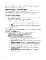
Under Current Settings, you can view the following items:
Device—Displays the current, active GPS device (or the last selected device).
Coordinates—Displays the coordinates of the last acquired location by the GPS device in the
coordinate format defined on the Units dialog area in the Map Display tab.
Note
: When the product is first used, the coordinates displayed are for DeLorme, in Yarmouth,
Maine.
Date and Time—Displays the system date and time, unless you have manually adjusted the date
and/or time manually.
Initializing GPS
The initializing process can take several minutes before the program detects the correct communications (COM) port
and updates the current settings.
To Initialize Your GPS Receiver
Use the following procedure to initialize your GPS receiver for use with Street Atlas USA 2005.
1.
Click the
GPS
tab and then click
Settings
to open the GPS Settings dialog area.
2.
Click
Clear Trail
to delete any GPS points from the current map display.
3.
Click
Options
. The Options dialog box displays.
4.
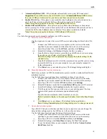
Select any or all of the following check boxes and click
OK
when finished:
Start GPS Log
—When selected, automatically generates a GPS log.
Use High-Contrast Colors
—When selected, automatically enables high-contrast map colors.
Magnify Map
—When selected, automatically magnifies the map view to the specified
magnification (125%, 150%, 175%, or 200%).
Recenter Map on GPS
—When selected, automatically centers the map on the GPS when you pan
the map.
Rotate Map in GPS Direction
—When selected, automatically rotates the map while the GPS is
on and moving or when playing back a GPS log. The direction of travel is indicated at the top of
the screen.
Show GPS Bread-Crumb Trail
—When selected, automatically displays your GPS progress on
the map as a "bread-crumb" trail up to the maximum specified number of points (5000 points is
approximately one hour and 20 minutes worth of points).
Enable GPS Voice Navigation
—When selected, provides spoken directions when tracking a
route with a GPS receiver.
Recalculate When Off Route
—When selected, automatically recalculates the route by the
designated threshold distance when the GPS is off of the route.
Start GPS with the Program
—When selected, starts GPS tracking automatically each time
Street Atlas USA 2005 is opened.

