26.10 Glossary of weather terms
Term
Definition
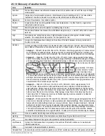
Cold front
The boundary between two different air masses where cold air pushes warm air out of the way and brings
colder weather.
Cyclone
A large area of low atmospheric pressure, characterized by inward spiralling winds. A “low” also called a
“depression”. Also the name used for a hurricane in the Indian Ocean and Western Pacific.
Depression
An area of low pressure. Also called a cyclone.
Dry line
A region where there is a strong gradient in dew point temperatures. It is often found in a region where
strong thunderstorms develop.
Forecast
Something that tells us what the weather is probably going to be like.
Front
The boundary between two masses of air with different temperatures (i.e. a mass of cold air and a mass of
warm air).
High
Also known as an 'anticyclone' an area of high atmospheric pressure with a system of winds rotating
outwards. This usually means dry weather. It is the opposite of a 'low'.
High Pressure
A mass of air that presses down strongly on the surface of the Earth because it is being cooled and is
therefore more dense.
Hurricane
A violent, spiralling storm that forms over the Atlantic Ocean, with winds over 120 kph. Such storms usually
have a lifespan of several days. Also known as a typhoon or tropical cyclone. There are 5 levels of hurricane:
•
Category 1
— Winds 74–95 mph (64–82 kt or 119–153 km/hr). Storm surge generally 4–5 ft above normal.
No real damage to building structures. Damage primarily to unanchored mobile homes, shrubbery, and
trees. Some damage to poorly constructed signs. Also, some coastal road flooding and minor pier damage.
•
Category 2
— Winds 96–110 mph (83–95 kt or 154–177 km/hr). Storm surge generally 6–8 feet above
normal. Some roofing material, door, and window damage of buildings. Considerable damage to shrubbery
and trees with some trees blown down. Considerable dam age to mobile homes, poorly constructed signs,
and piers. Coastal and low lying escape routes flood 2–4 hours before arrival of the hurricane centre Small
craft in unprotected anchorages break moorings.
•
Category 3
— Winds 111–130 mph (96–113 kt or 178–209 km/hr). Storm surge generally 9–12 ft above
normal. Some structural damage to small residences and utility buildings with a minor amount of curtain
wall failures. Damage to shrubbery and trees with foliage blown off trees and large trees blown down.
Mobile homes and poorly constructed signs are destroyed. Low lying escape routes are cut by rising water
3–5 hours before arrival of the centre of the hurricane. Flooding near the coast destroys smaller structures
with larger structures damaged by battering from floating debris. Terrain continuously lower than 5 ft above
mean sea level may be flooded inland 8 miles (13 km) or more. Evacuation of low lying residences with
several blocks of the shoreline may be required.
•
Category 4
— Winds 131–155 mph (114–135 kt or 210–249 km/hr). Storm surge generally 13–18
ft above normal. More extensive curtain wall failures with some complete roof structure failures on
small residences. Shrubs, trees, and all signs are blown down. Complete destruction of mobile homes.
Extensive damage to doors and windows. Low lying escape routes may be cut by rising water 3–5 hours
before arrival of the centre of the hurricane. Major damage to lower floors of structures near the shore.
Terrain lower than 10 ft above sea level may be flooded requiring massive evacuation of residential
areas as far inland as 6 miles (10 km).
•
Category 5
— Winds greater than 155 mph (135 kt or 249 km/hr). Storm surge generally greater than 18 ft
above normal. Complete roof failure on many residences and industrial buildings. Some complete building
failures with small utility buildings blown over or away. All shrubs, trees, and signs blown down. Complete
destruction of mobile homes. Severe and extensive window and door damage. Low lying escape routes
are cut by rising water 3–5 hours before arrival of the centre of the hurricane. Major damage to lower floors
of all structures located less than 15 ft above sea level and within 500 yards of the shoreline. Massive
evacuation of residential areas on low ground within 5–10 miles (8–16 km) of the shoreline may be required.
Isobar
A line on a weather map linking areas with equal air pressure.
Lightning
Discharge of static electricity in the atmosphere, usually between the ground and a storm cloud.
Low
Also called a 'depression' this region of low pressure can mean wet weather.
Low Pressure
A mass of air that presses down only weakly on the surface of the Earth’s surface as it is warmed and
it therefore less dense.
Millibar
A unit used to measure atmospheric pressure.
Occluded Front
An area where warm air is pushed upwards as a cold front overtakes a warm front and pushes underneath it.
Weather application (North America only)
393
Summary of Contents for c125
Page 2: ......
Page 14: ...14 a Series c Series e Series ...
Page 41: ...13 GPS receiver 14 Thermal camera 15 Wireless connection Planning the installation 41 ...
Page 48: ...48 a Series c Series e Series ...
Page 80: ...80 a Series c Series e Series ...
Page 118: ...118 a Series c Series e Series ...
Page 184: ...184 a Series c Series e Series ...
Page 188: ...188 a Series c Series e Series ...
Page 206: ...206 a Series c Series e Series ...
Page 228: ...228 a Series c Series e Series ...
Page 290: ...290 a Series c Series e Series ...
Page 310: ...310 a Series c Series e Series ...
Page 340: ...340 a Series c Series e Series ...
Page 374: ...374 a Series c Series e Series ...
Page 422: ...422 a Series c Series e Series ...
Page 436: ...436 a Series c Series e Series ...
Page 462: ...462 a Series c Series e Series ...
Page 463: ......
Page 464: ...www raymarine com ...


