604
442704/A
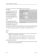
provided by a GIS database. [] A WMS server usually serves the map in a bitmap
format, e.g. PNG, GIF, JPEG, etc. In addition, vector graphics can be included,
such as points, lines, curves and text, expressed in SVG or WebCGM format.
https://en.wikipedia.org/wiki/Web_Map_Service, June 2021
Related functionality
Map function
This is an "on/off" switch. Use
Map
to enable or disable the geographical map layer.
This function is opened from the
Cosmetics
menu.
Map Display page
Once a map service has been chosen, use
Map Display
to choose which map elements
to include in the map presentation. This page is located in the
Display Options
dialog
box. The
Display Options
dialog box is located on the
Display
menu.
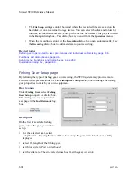
Safety Depth page
The
Safety Depth
page allows you to change the safety depth settings, and thus the
presentation of the various water depths.
Range Projection function
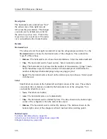
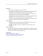
The distance to a target located anywhere in the water column can be measured in two
ways. This can either be the horizontal distance to the target (
True
), or along the tilt
angle (
Slant
). The
Range Projection
function defines how this distance is measured.
This function is opened from the
Active
menu.
Related topics
Using maps, page 152
Functions and dialog boxes, page 416
Setup menu; Functions and dialog boxes, page 452
Installation dialog box, page 464
Cosmetics menu, page 409
Map Display page, page 533
Safety Depth page, page 535
Simrad ST90 Reference Manual
Summary of Contents for Simrad ST90
Page 1: ...kongsberg com simrad Simrad ST90 REFERENCE MANUAL ...
Page 2: ......
Page 337: ...442704 A 335 Related topics Sonar views page 326 User interface ...
Page 413: ...442704 A 411 Related topics Menu system page 375 Display menu page 384 Menu system ...
Page 631: ...442704 A 629 Related topics Concept descriptions page 626 Concept descriptions ...
Page 687: ......
Page 688: ... 2021 Kongsberg Maritime ISBN 978 82 8066 211 8 ...
Page 689: ......
Page 690: ...Reference Manual Simrad ST90 ...

