3.6 DISPLAY USER MAP
y
yy
3-35
3
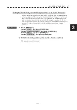
Setting the Geodetic System for Navigation Data to be Saved (Geodetic)
To create navigation information, set the geodetic system that is used with the connected
navigation equipment. When navigation information is loaded, the geodetic system used
when the navigation information was saved, is displayed. Make sure that the displayed
geodetic system is identical to the one used with the navigation equipment. If the two
geodetic systems are different, the positions of navigation information of the display will
be shifted. Therefore, it is important to set the geodetic system of the navigation
equipment.
Procedures
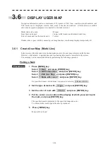
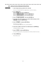
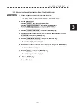
1 Press [MENU] key.
Select 8.Next and press [ENTER] key.
Select 4.NAV Information and press [ENTER] key.
Select 6.Next and press [ENTER] key.
Select 2.Geodetic and press [ENTER] key.
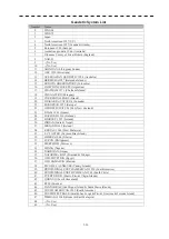
2 Enter the desired geodetic system number. (See the next list)
The geodetic system is determined.
Summary of Contents for JMR-611
Page 2: ......
Page 24: ......
Page 26: ......
Page 28: ......
Page 33: ...1 5 1 1 4 EXTERIOR DRAWINGS y Fig 1 1 Exterior Drawing of Scanner Unit Type NKE 387 Unit mm...
Page 34: ...1 6 Fig 1 2 Exterior Drawing of Processing Unit Type NDC 1774 Unit mm...
Page 35: ...1 7 1 1 4 EXTERIOR DRAWINGS y Fig 1 3 Exterior Drawing of Operating Unit Type NCE 5923 Unit mm...
Page 38: ......
Page 54: ......
Page 116: ......
Page 118: ......
Page 124: ......
Page 134: ......
Page 136: ......
Page 142: ......
Page 144: ......
Page 154: ......
Page 156: ......
Page 160: ......
Page 164: ......
Page 166: ......
Page 172: ......
Page 174: ......
Page 177: ...APPENDIX Fig 1 Block Diagram of JMR 611...
Page 181: ...APPENDIX Fig 5 Internal Connection Diagram of Control Unit NCM 994...
Page 182: ......
Page 184: ......
Page 186: ......
Page 187: ......

