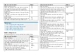
Menu item and description
Options
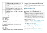
[Marine protected areas]
Allows clear identification of areas where commercial
and recreational fishing is prohibited or restricted.
This setting is available when using C-MAP® charts.
•
On
•
Off
[Fishing AOI]
Enables and disables the display of Fishing AOIs (Areas
Of Interest).
This setting is available when using LightHouse™ and
C-MAP® charts.
•
On
•
Off
[ActiveCaptain]
Enables and disables the display of crowd-sourced data.
This setting is available when using C-MAP® charts.
•
On
•
Off
Related topics:
•
p.211 — Navigate mode settings menus
•
p.214 — Fishing chart mode settings menus
•
p.218 — Anchor mode settings menus
•
p.228 — Racing mode settings menus
Depth settings menu
The depth settings menu contains depth contour related settings.
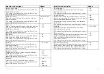
Menu item and description
Options
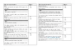
[Show soundings]
Enables and disables the display of depth soundings on
the chart. When set to
[Manual]
, depth soundings will be
shown from
[Zero to]
the maximum depth you specify.
This setting is not available for Raster charts
•
None
•
Manual
•
All
[Show contours]
Enables and disables the display of depth contours on
the chart. When set to Manual, contours will be shown
from zero to the maximum depth you specify.
This setting is available when using LightHouse™,
C-MAP® and Navionics® vector charts.
•
None
•
Manual
•
All
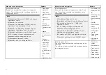
Menu item and description
Options
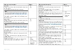
[Shallow contour]
Determines the depth at which the Shallow contour is
displayed. The Shallow contour cannot be set to a value
greater than the Safe contour or Deep contour value.
This setting is available when using LightHouse™, legacy
LightHouse™ and S-63 vector charts.
Numeric depth
value
[Safe contour]
Determines the depth at which the Safe contour is
displayed.
The Safe contour cannot be set to a value that is less
than the Shallow contour or greater than the Deep
contour.
This setting is available when using LightHouse™, legacy
LightHouse™ and S-63 vectors charts.
Numeric depth
value
[Shallow area]
Enables and disables identification of areas deemed
to be shallow. When enabled, a red hatched area is
displayed in areas shallower than the depth specified
in the
[Zero to]
field.
This setting is available when using Navionics® charts.
•
On
•
Off
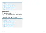
[Deep contour:]
Determines the depth at which the deep contour is
shown. E.g. if you set this to a value of 30 meters,
any water with a depth greater than 30 meters will be
displayed as a deep contour.
This setting is not available for Raster charts.
Numeric depth
value
[Depth gradient]
Allows you to specify the gradient shade between
shallow and deep.
This setting is available when using LightHouse™ and
legacy LightHouse™ vector charts.
•
Dark to light
•
Light to dark
[Deep water color]
Allows you to specify the color that will be used to
display Deep water.
This setting is available when using C-MAP® and
Navionics® charts.
•
White
•
Blue
204
Содержание LIGHTHOUSE 4
Страница 2: ......
Страница 4: ......
Страница 20: ...APPENDIX C HARDWARE AND SOFTWARE COMPATIBILITY 478 APPENDIX D DOCUMENT CHANGE HISTORY 480 20...
Страница 414: ...414...
Страница 451: ...4 Select Delete again to confirm 5 Select OK YachtSense ecosystem 451...
Страница 484: ......
Страница 503: ......

