


SonTek/YSI Inc
RiverSurveyor System Manual (May 1, 2007)
107
Configuration
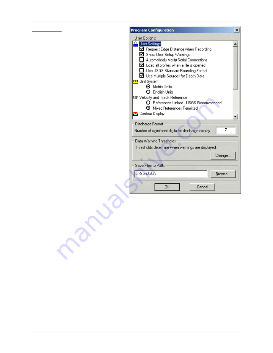
This item lets you set program control op-
tions and user preferences.
shows the options available. Defaults are in
[brackets].
•
User Settings
:
-
Request Edge Distance when Re-
cording
[enabled] – Show the
Start
Edge
and
End Edge
dialog boxes
when the
Record
button is pressed
during real-time data collection. See
§
for more information.
-
Show User Setup Warnings
[enabled]
– Show a
Warnings
dialog box if any
User Setup
parameters are question-
able. See §
for information.
-
Automatically Verify Serial Connec-
tions
[disabled] – Verify serial con-
nections to all systems as soon as the
communications parameters have
been set in the
System
dialog box.
See §
for more information.
-
Load all profiles when a file is
opened
[enabled] – A file will auto-
matically load and display all pro-
files when it is opened.
-
Use USGS Standard Rounding For-
mat
[enabled] – Use the U.S. Geo-
logical Survey’s standard rounding format for all parameters displayed in the Discharge
Measurement Summary (§
-
Use Multiple Sources for Depth Data
[enabled] – When both bottom-track and echo
sounder depth data are present, and one is invalid, the other source will be used for depth
values.
•
Unit System
– All graphs, data displays, and export files use the selected unit system:
-
Metric Units
[default] – Show values in metric units (meters, dbar, °C)
-
English Units
– Show values in English units (feet, psi, °F)
•
REF Velocity and Track Reference
:
-
References Linked - USGS Recommended
[default] – The reference for both the track and
the velocity will always be the same. If the track or velocity reference is changed, the
other reference will also change. The U.S. Geological Survey recommends this option.
-
Mixed References Permitted
– The references for track and velocity do not have to be the
same, and will not be automatically updated if one is changed.
•
Contour Display
– These options relate to the display of the
-
Show Bottom Depth on Contour Graph
[enabled] – Show the region below the water (the
river or sea bed) as a solid-color area.
Figure 7-18.
Program Configuration
dialog box
Summary of Contents for SonTek RiverSurveyor
Page 2: ...SonTek YSI Inc RiverSurveyor System Manual May 1 2007 ii ...
Page 4: ...SonTek YSI Inc RiverSurveyor System Manual May 1 2007 iv ...
Page 14: ......
Page 24: ...SonTek YSI Inc RiverSurveyor System Manual May 1 2007 12 ...
Page 26: ...SonTek YSI Inc RiverSurveyor System Manual May 1 2007 14 ...
Page 74: ...SonTek YSI Inc RiverSurveyor System Manual May 1 2007 62 ...
Page 82: ...SonTek YSI Inc RiverSurveyor System Manual May 1 2007 70 ...
Page 148: ...SonTek YSI Inc RiverSurveyor System Manual May 1 2007 136 ...
Page 162: ...SonTek YSI Inc RiverSurveyor System Manual May 1 2007 150 ...
Page 166: ...SonTek YSI Inc RiverSurveyor System Manual May 1 2007 154 ...
Page 168: ...SonTek YSI Inc RiverSurveyor System Manual May 1 2007 156 ...
Page 182: ...SonTek YSI Inc RiverSurveyor System Manual May 1 2007 170 ...
Page 194: ...SonTek YSI Inc RiverSurveyor System Manual May 1 2007 182 ...


