


SonTek/YSI Inc
RiverSurveyor System Manual (May 1, 2007)
122
7.5.
Waypoints and Navigation
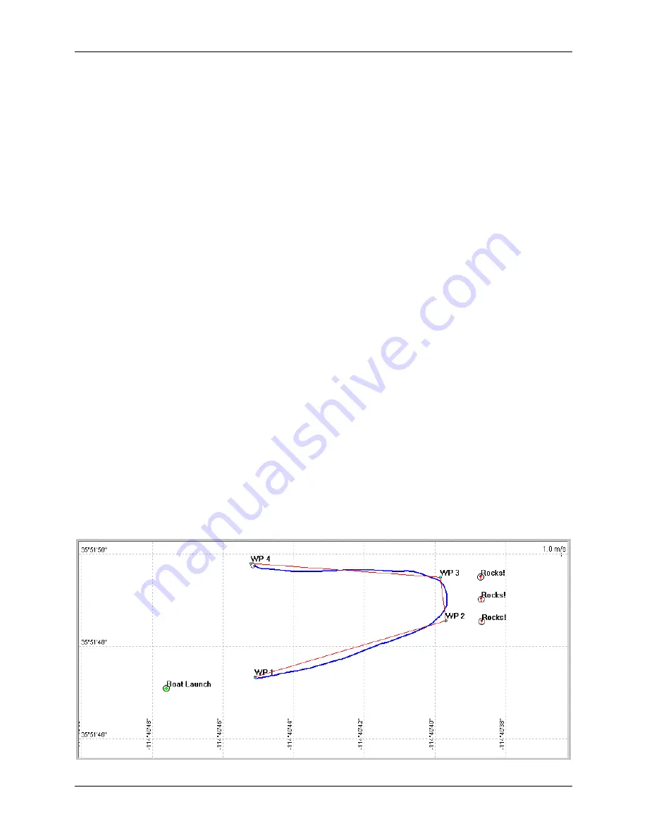
Waypoints and navigational features are locations that can be set in the
(§
assist in navigation during a discharge measurement. For example,
shows the
with waypoints (
WP1
,
WP2
,
WP3
,
WP4
), a marker (
Boat Launch
), hazards (
Rocks!
), a
proposed navigational route (3-legged, red line), and the vessel’s actual path (curved blue line).
There are three basic features that can be used:
•
Waypoints
– Select key points along a navigational route. This route can be followed and
repeated from one measurement to another.
•
Markers
– Highlight locations of interest such as buoys or markers.
•
Hazards
– Identify potential dangers such as rocks or sub-surface hazards that may not be
obvious during the measurement.
A waypoint/marker/hazard is identified by the following characteristics:
•
Name – Usually used to label a location or a “node” along a route. The name is displayed
over the waypoint/marker on the
.
•
Position – Latitude and longitude of the waypoint.
•
Comments – Any additional information. The comments of a waypoint can be viewed by
moving the mouse over the waypoint’s symbol.
There are advantages to using waypoints for water current/depth surveys and measurement tran-
sects along significantly long routes. Though waypoints can be entered and viewed when the
reference is set to
Bottom Track
(i.e., absolute (0,0) coordinates), we recommend
that waypoints only be used in GPS coordinates (latitude/longitude). Waypoints should only be
viewed in bottom-track mode as a means of comparison with GPS track data.
When waypoints are used, a line will be displayed (by default) that connects each of the points.
This line can be used as a navigational route that can be followed during the measurement. An
option to show/hide the line can be found in
File|Configuration|Track Display|Draw connection
between Waypoints
.
New waypoints may be added by using the mouse or the
View|Show Waypoints (Ctrl+W)
menu
and dialog box (
Figure 7-32. Waypoints used as navigational aides in Track Window
Summary of Contents for SonTek RiverSurveyor
Page 2: ...SonTek YSI Inc RiverSurveyor System Manual May 1 2007 ii ...
Page 4: ...SonTek YSI Inc RiverSurveyor System Manual May 1 2007 iv ...
Page 14: ......
Page 24: ...SonTek YSI Inc RiverSurveyor System Manual May 1 2007 12 ...
Page 26: ...SonTek YSI Inc RiverSurveyor System Manual May 1 2007 14 ...
Page 74: ...SonTek YSI Inc RiverSurveyor System Manual May 1 2007 62 ...
Page 82: ...SonTek YSI Inc RiverSurveyor System Manual May 1 2007 70 ...
Page 148: ...SonTek YSI Inc RiverSurveyor System Manual May 1 2007 136 ...
Page 162: ...SonTek YSI Inc RiverSurveyor System Manual May 1 2007 150 ...
Page 166: ...SonTek YSI Inc RiverSurveyor System Manual May 1 2007 154 ...
Page 168: ...SonTek YSI Inc RiverSurveyor System Manual May 1 2007 156 ...
Page 182: ...SonTek YSI Inc RiverSurveyor System Manual May 1 2007 170 ...
Page 194: ...SonTek YSI Inc RiverSurveyor System Manual May 1 2007 182 ...


