A-7
Appendix
ProMARK X
Differential GPS
Most DGPS techniques use a GPS receiver at a geodetic control site whose
position is known. The receiver collects positioning information and
calculates a position fix, which is then compared to the known coordinates.
The difference between the known position and the acquired position of the
control location is the positioning error.
Because the other GPS receivers in the area are assumed to be operating
under similar conditions, it is assumed that the position fixes acquired by
other receivers in the area (remote units) are subject to the same error, and
that the correction computed for the control position should therefore be
accurate for those receivers. The correction is communicated to the remote
units by an operator at the control site with radio or cellular equipment. (In
post-processed differential, all units collect data for off-site processing; no
corrections are determined in the field.)
Some have had success in separating the control and remote units by over
1,000 kilometers; because all of the GPS receivers must be using the same
satellite set and because tropospheric corrections are limited, we do not
recommend any separation greater than 50 kilometers.
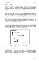
CONTROL UNIT
REMOTE UNIT
(Reference Position)
N
X (Position Obtained
with Control Unit)
(Corrected Position)
X (Position Obtained
with Remote Unit
Delta
A Position Error Corrected with Differential
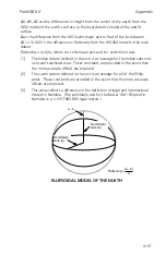
The difference between the known position and the acquired position at the
control point is the DELTA correction. DELTA, which is always expressed in
meters, is parallel to the surface of the earth. When expressed in a local
coordinate system, DELTA uses a North-South axis (y) and an East-West axis
(x) in 2D operation; an additional vertical axis (z) that is perpendicular to the
y and x axes is used in 3D operation for altitude.
Summary of Contents for GPS PROMARK X
Page 4: ......
Page 10: ...vi...
Page 14: ...Introduction ProMARK X 1 4...
Page 92: ...Attributes ProMARK X 6 8...
Page 188: ......


