A-27
Appendix
ProMARK X
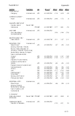
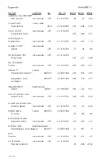
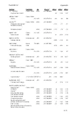
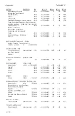
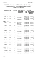
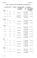
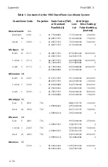
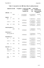
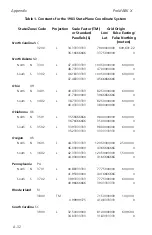
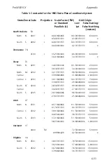
Table 1. Constants for the 1983 State Plane Coordinate System
State/Zone/Code
Projection
Scale Factor (TM)
Grid Origin
or Standard
Lon/
False Easting/
Parallels (L)
Lat
False Northing
(meters)
Arkansas
AR
North
N
0301
L
34.93333333
92.00000000
400,000.
36.23333333
34.33333333
0
South
S
0302
L
33.30000000
92.00000000
400,000.
34.76666666
32.66666666
400,000.
California
CA
Zone 1
0401
L
40.00000000
122.00000000
2,000,000.
41.66666666
39.33333333
500,000.
Zone 2
0402
L
38.33333333
122.00000000
2,000,000.
39.83333333
37.66666666
500,000.
Zone 3
0403
L
37.06666666
120.50000000
2,000,000.
38.43333333
36.50000000
500,000.
Zone 4
0404
L
36.00000000
119.00000000
2,000,000.
37.25000000
35.33333333
500,000.
Zone 5
0405
L
34.03333333
118.00000000
2,000,000.
35.46666666
33.50000000
500,000.
Zone 6
0406
L
32.78333333
116.25000000
2,000,000.
33.88333333
32.16666666
500,000.
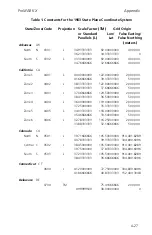
Colorado
CO
North
N
0501
L
39.71666666
105.50000000
914,401.8289
40.78333333
39.33333333
304,800.6096
Central C
0502
L
38.45000000
105.50000000
914,401.8289
39.75000000
37.83333333
304,800.6096
South
S
0503
L
37.23333333
105.50000000
914,401.8289
38.43333333
36.66666666
304,800.6096
Connecticut
CT
0600
L
41.20000000
72.75000000
304,800.6096
41.86666666
40.83333333
152,400.3048
Delaware
DE
0700
TM
75.41666666
200,000.
0.99999500
38.00000000
0
Summary of Contents for GPS PROMARK X
Page 4: ......
Page 10: ...vi...
Page 14: ...Introduction ProMARK X 1 4...
Page 92: ...Attributes ProMARK X 6 8...
Page 188: ......

