A-41
Appendix
ProMARK X
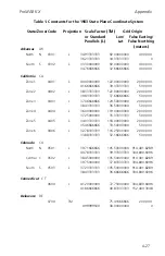
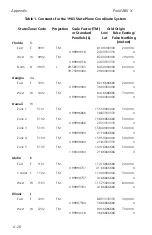
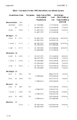
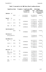
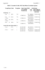
Table 2. Constants for the 1927 State Plane Coordinate System
State/Zone/Code
Projection
Scale Factor (TM)
Grid Origin
or Standard
Lon/
False Easting/
Parallels (L)
Lat
False Northing
(meters)
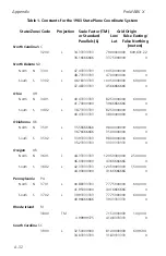
New York
NY
East
E
3101
TM
74.33333333
152400.3048
0.99996666
40.00000000
0
Central C
3102
TM
76.58333333
152400.3048
0.99993750
40.00000000
0
West
W
3103
TM
78.58333333
152400.3048
0.99993750
40.00000000
0
Long
L
3104
L
40.66666666
74.00000000
609601.2192
Island
41.03333333
40.50000000
30480.06096
North Carolina
NC
3200
L
34.33333333
79.00000000 609,601.2192
36.16666666
33.75000000
0
North Dakota
ND
North
N
3301
L
47.43333333
100.50000000
609601.2192
48.73333333
47.00000000
0
South
S
3302
L
46.18333333
100.50000000
609601.2192
47.48333333
45.66666666
0
Ohio
OH
North
N
3401
L
40.43333333
82.50000000
609601.2192
41.70000000
39.66666666
0
South
S
3402
L
38.73333333
82.50000000
609601.2192
40.03333333
38.00000000
0
Oklahoma
OK
North
N
3501
L
35.56666666
98.00000000
609601.2192
36.76666666
35.00000000
0
South
S
3502
L
33.93333333
98.00000000
609601.2192
35.23333333
33.33333333
0
Oregon
OR
North
N
3601
L
44.33333333
120.50000000
609601.2192
46.00000000
43.66666666
0
South
S
3602
L
42.33333333
120.50000000
609601.2192
44.00000000
41.66666666
0
Summary of Contents for GPS PROMARK X
Page 4: ......
Page 10: ...vi...
Page 14: ...Introduction ProMARK X 1 4...
Page 92: ...Attributes ProMARK X 6 8...
Page 188: ......

