


Appendix
ProMARK X
A-54
MASK ANGLE
The elevation (height above the
horizon, measured in degrees),
below which the unit will not
search for satellites. The mask
angle is selected by the user in
SETUP.
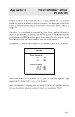
PDOP
Position Dilution of Precision.
POSITION
A location that is obtained in real
time and expressed in a coordinate
system. Sometimes called a fix. Also
a waypoint location obtained from
a chart or other source.
POSITION DILUTION OF
A measurement of possible
PRECISION
geometric error, and abbreviated
PDOP. See
Appendix 10
and
Error/
Warning Messages
.
PSEUDORANGE DATA
Data on the precise location of a
satellite in relation to the receiver.
Used to calculate a position fix,
then discarded by the unit.
RECEIVER
The electronic components of the
ProMARK X that receive satellite
signals.
ROUTE
A planned course of travel, divided
into one to ten legs, each with its
own start and destination.
ROUTE LEG
A portion of a route.
SIGNAL QUALITY
An indication of the signal-to-noise
ratio of each satellite signal being
used, and abbreviated as SQ.
Ranges from 0 (lowest) to 9
(highest). A scale for indicating the
strength of the signal, and the
likelihood of the lock on the signal
being lost. See
Appendix 11
and
Error/Warning Messages
.
Summary of Contents for GPS PROMARK X
Page 4: ......
Page 10: ...vi...
Page 14: ...Introduction ProMARK X 1 4...
Page 92: ...Attributes ProMARK X 6 8...
Page 188: ......


