


Waypoints, Routes & Navigation
ProMARK X
5-1
Chapter 5
WAYPOINTS, ROUTES, AND
NAVIGATION
GPS technology originated from the need for a precise navigational system,
and for that reason the ProMARK X is able to offer navigational functions.
If your applications does not require a need for the navigational functions of
the ProMARK X, you may want to read the section in this chapter on
waypoints and bypass the remaining sections until needed.
This chapter will introduce the concepts of waypoints, routes, and naviga-
tion. The topic of waypoints will be presented first followed by a discussion
of routes and then navigation. These topics are all closely related in that
waypoints are needed to set routes and routes are needed to navigate.
WAYPOINT
A waypoint is position coordinates that have been saved, usually so you can
return to the same position. The ProMARK X allows you to name and store
waypoints in its memory, either by saving a position fix or a fix from the
buffer, or by manually keying in coordinates that have been picked up from
a map or received from a colleague.
Waypoints can also be viewed, deleted, and renamed. They are stored in
alphanumeric order.
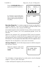
Saving Positions as Waypoints
. Use the following key sequence to save
a position as a waypoint.
Obtain a position fix with
POS
.
Press
ENTER
. A cursor appears in
the upper left corner on the mes-
sage display. Key in a 1- to 4-
character name (as described in
Entering Data)
followed by
ENTER
.
If the name you chose is already
being used, the unit displays “DU-
PLICATE NAME.” Press
ENTER
and
key in another name.
MESA 32`26.67N
118`29.99W
3D 172m ALT
~
Summary of Contents for GPS PROMARK X
Page 4: ......
Page 10: ...vi...
Page 14: ...Introduction ProMARK X 1 4...
Page 92: ...Attributes ProMARK X 6 8...
Page 188: ......


