


A-25
Appendix
ProMARK X
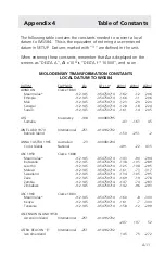
Appendix 7
STATE PLANE COORDINATE
SYSTEM CONSTANTS
The Field PRO V can display position coordinates in the State Plane
Coordinate System (SPCS) for 1983 or 1927 when a user-entered
coordinate system (grid) is entered with SETUP 7.
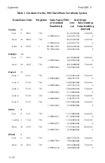
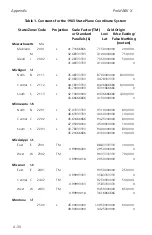
This appendix consists of two tables that contain the constants necessary
to enter an SPCS83 or SPCS27 grid. Please note that all units of measure
in this table are in meters; conversion to feet is dependent on whether
you are using SPCS83 or SPCS27, and on the zone being displayed. If you
will be using feet, check with the Survey Office of your state to verify
whether a U.S. Survey Foot or an International Foot is used in your area.
For your convenience:
U.S. Survey Foot = (1200/3937)m
International Foot = 0.3048m
When using the following tables, please note the following exceptions:
1.
Zones based on a Transverse Mercator Projection contain
a scale factor, while those based on a Lambert projection
contain two standard parallels.
2.
In a Transverse Mercator Projection, the Longitude of
Origin and the Central Meridian are the same; the terms
are sometimes used interchangeably.
3.
Zones based on the Transverse Mercator Projection in
SPCS27 have no False Northing.
4.
In SPCS83, zone 1 code 5001 is based on the Oblique
Mercator Projection, and is defined with point azimuth
equal to arc tan -3/4. This zone is not defined in SPCS27.
Please also not that LAT/LON (and standard parallel
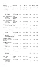
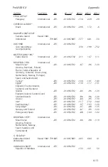
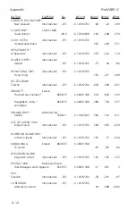
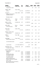
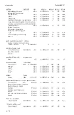
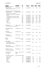
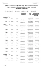
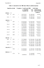
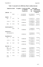
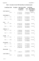
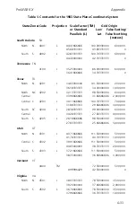
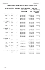
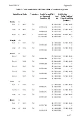
Table 1. Constants for
the 1983 State Plane Coordinate System
State/Zone/Code
Projection
Scale Factor (TM)
Grid Origin
or Standard
Lon/ False Easting/
Parallels (L)
Lat False Northing
(meters)
Summary of Contents for GPS PROMARK X
Page 4: ......
Page 10: ...vi...
Page 14: ...Introduction ProMARK X 1 4...
Page 92: ...Attributes ProMARK X 6 8...
Page 188: ......


