Getting Started
2-10
ProMARK X
NOTE
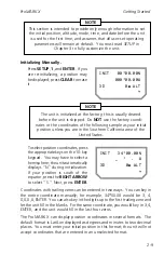
If you initialize in Lat/Lon coordinates, the default hemispheres are
North and West. The unit assumes that the hemispheres you
choose here (or the hemispheres calculated in the last position fix,
whichever is more recent) are current. These hemispheres are
offered as your first choice when you enter a waypoint manually.
Enter the longitude; use the
RIGHT
ARROW
to toggle between E and
W (if necessary), then press
EN-
TER.
INIT 34`00.00N
117`00.00W
3D 0m ALT
~!
If you will be using an external antenna, be sure to enter the antenna altitude.
Antenna altitude is the altitude of your position plus the height of the
antenna installation above you.
WARNING
Entering an incorrect altitude may introduce errors into the
position fixes produced by the unit; accepting the default
altitude of 0 meters when not at sea level will also introduce
errors.
Select a mode of operation and
enter your altitude. Press the
DOWN ARROW
and
ENTER
to
display the mode/altitude screen.
Use the
RIGHT ARROW
to display
the mode of operation you want to
use. For land use, we recommend
using the default 3D mode.
Now enter your current altitude.
The default altitude is 0 meters
(MSL). To enter a different alti-
tude, press
CLEAR
, then key in the
correct altitude. Use the
RIGHT
ARROW
to toggle between posi-
tive and negative values. Press
ENTER
.
MODE:3D (4 SATS)
SOLVE FOR ALT
0m ALT
~!
Summary of Contents for GPS PROMARK X
Page 4: ......
Page 10: ...vi...
Page 14: ...Introduction ProMARK X 1 4...
Page 92: ...Attributes ProMARK X 6 8...
Page 188: ......


