A-53
Appendix
ProMARK X
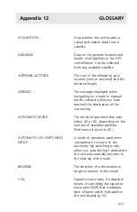
FIX
A single position, defined by
latitude, longitude, and altitude.
GROUND COURSE
See Course over ground.
GROUND SPEED
See Speed over ground.
HEADING
The direction your vessel is facing,
defined as an angle from North.
LAST FIX
The position fix taken before the
current position fix, stored in the
unit’s memory and accessed by
pressing AUX 6.
LATITUDE
The distance north or south of the
equator, measured in an arc with
the equator being 0
°
and the poles
being 90
°
. (The default latitude is
north.)
LONGITUDE
The distance east or west of the
prime meridian (0
°
), which inter-
sects Greenwich, England. The
range is 0
°
–180
°
E, moving east
of 0
°
, and 0
°
–180
°
W, moving
west of 0
°
. (The default longitude is
west.)
MANUAL LEG SWITCHING MODE
A mode of operation used when
navigating on a route. In the
manual leg switching mode, when
you pass the leg's destination, the
screen displays "ARRIVED" on the
fourth line. The unit must be
switched to the next leg manually
by pressing the RIGHT ARROW.
MAP DATUM
A method of assigning position
coordinates to real-world locations.
Based on an underlying ellipsoidal
model of the earth, and subject to
other scientific assumptions.
Identified by a unique name, such
as WGS84 or NAD27.
Summary of Contents for GPS PROMARK X
Page 4: ......
Page 10: ...vi...
Page 14: ...Introduction ProMARK X 1 4...
Page 92: ...Attributes ProMARK X 6 8...
Page 188: ......


