Appendix
ProMARK X
A-38
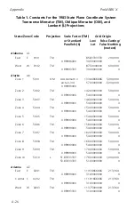
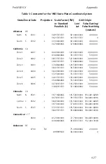
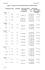
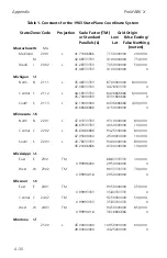
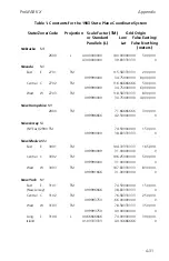
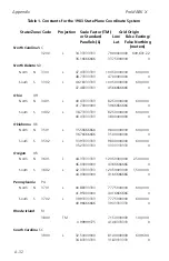
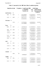
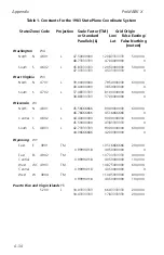
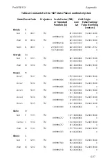
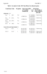
Table 2. Constants for the 1927 State Plane Coordinate System
State/Zone/Code
Projection
Scale Factor (TM)
Grid Origin
or Standard
Lon/
False Easting/
Parallels (L)
Lat
False Northing
(meters)
Indiana
IN
East
E
1301
TM
85.66666666
152400.3048
0.99996666
37.50000000
0
West
W
1302
TM
87.08333333
152400.3048
0.99996666
37.50000000
0
Iowa
IA
North
N
1401
L
42.06666666
93.50000000
609601.2192
43.26666666
41.50000000
0
South
S
1402
L
40.61666666
93.50000000
609601.2192
41.78333333
40.00000000
0
Kansas
KS
North
N
1501
L
38.71666666
98.00000000
609601.2192
39.78333333
38.33333333
0
South
S
1502
L
37.26666666
98.50000000
609601.2192
38.56666666
36.66666666
0
Kentucky
KY
North
N
1601
L
37.96666666
84.25000000
609601.2192
38.96666666
37.50000000
0
South
S
1602
L
36.73333333
85.75000000
609601.2192
37.93333333
36.33333333
0
Louisiana
LA
North
N
1701
L
31.16666666
92.50000000
609601.2192
32.66666666
30.66666666
0
South
S
1702
L
29.30000000
91.33333333
609601.2192
30.70000000
28.66666666
0
Offshore
1703
L
26.16666666
91.33333333
609601.2192
27.83333333
25.66666666
0
Maine
ME
East
E
1801
TM
68.50000000
152400.3048
0.99990000
43.83333333
0
West
W
1802
TM
70.16666666
152400.3048
0.99996666
42.83333333
0
Summary of Contents for GPS PROMARK X
Page 4: ......
Page 10: ...vi...
Page 14: ...Introduction ProMARK X 1 4...
Page 92: ...Attributes ProMARK X 6 8...
Page 188: ......


