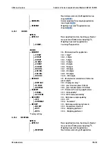
— GEOG.DAT
1.20 - Calibration site (geographical data, or
alternatively, gravitational acceleration at
installation site)
SM)
— BREITE
1.20.1 - Latitude in degrees
— HOEHE
1.20.2 - Altitude in meters above sea level
— ERDBES.
1.20.3 - Gravity
— SPEICH.
1.20.4 - Save parameters
acceleration (menu item [ERDBES.] 1.20.3) can be entered. Here, the gravitational
acceleration has priority over latitude and altitude: If it is entered, 99999.99 is
displayed for the latitude and 9999999 for the altitude. If only the altitude and
latitude are entered, 0000000 appears for the gravitational acceleration.
Note:
Returning to the top menu level of the numeric menu without irst saving the
coniguration parameters (menu item [SPEICH.] 1.20.4) deletes all settings entered
previously.
Menu tree for entering geographical data
Menu: [SETUP]- [WP-1]- [INTERN.]- [PARAM.1]- [GEOG.DAT] (1.20) (see also
Chapter
SM)
only visible in service mode
Procedure
If the device is part of a veriied weighing system, this can only be done by breaking
the seal. The scale must then be re-calibrated.
The data can be obtained from the land registry or the land surveying authority.
1. Open the locking switch (see Chapter
2. Activate service mode (see Chapter
3. Select the weighing platform.
4. Enter the geographical data for the calibration site under menu item [GEOG.DAT]
1.20.1 … 1.20.3 and save it under menu item [SPEICH.] 1.20.4(see also
Chapter
).
5. Perform external calibration (see Chapter
).
6. After calibration, enter the geographical data for the installation site under menu
item [GEOG.DAT] 1.20.1 … 1.20.3 and save it under menu item [SPEICH.] 1.20.4(see
also Chapter
7. Close the locking switch.
The scale can now be operated at the installation site, including the tolerance
zone speciied above.
Combics 2 Series Complete Scales Models CAW2P, CAW2S
5 Getting started
EN-50
Minebea Intec


