


8. Manual Updates
8-18
8.5.3
Modifying chart objects
The mariner cannot permanently remove from the chart display any of the official chart objects, but he can modify
position and/or properties of chart objects. When the mariner modifies a chart object, the chart radar will mark
original chart object as deleted and a copy of original chart object as inserted.
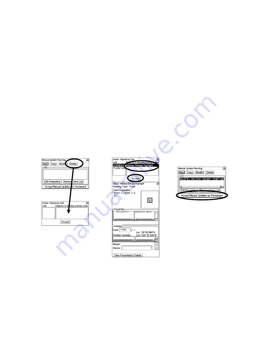
1. Follow steps 1-3 on page 8-6 to display the Manual Update Planning dialog box.
2. Click the
Modify
button.
3. Place the cursor on the desired object then push the left button.
4. Choose the object from the Objects by Cell window. Confirm data for selected object.
5. Click the
Accept
button.
6. Click the
Edit Properties
button.
7. If you want to modify the position of the object, click the
Edit Position
button. Otherwise continue from step 13.
8. Place the cursor on the desired location on the chart radar display. Click the
Accept
button.
9. Click
Accept Manual Updates as Permanent
. If you want to modify also properties continue from step 10.
10. If you want to modify properties, also click
Accept
.
11. If you want to modify the properties of the object click
Edit Properties and values
button. Otherwise continue
from step 9.
12. Pick from the list properties you want to modify and give them new values. You can also add new properties or
remove old.
13. Click
Accept List and values
to continue from step 5 or 11 again. Otherwise continue from step 9.
2.
4.
5.
6.
3. Place cursor on
desired object and
press left mouse button.
3.
Содержание FCR-2107 series
Страница 42: ...1 Operational Overview 1 20 This page intentionally left blank...
Страница 73: ...2 Radar Operation 2 31 ROUGH SEA SHIP HARBOR COAST Picture setup options and default settings con t...
Страница 154: ...5 AIS Operation 5 28 This page intentionally left blank...
Страница 253: ...7 Vector Chart Material 7 81 More information is available in text More information is available as a picture...
Страница 255: ...7 Vector Chart Material 7 83 Recommended track defined by two beacons...
Страница 256: ...7 Vector Chart Material 7 84 Recommended track defined by a building and a beacon...
Страница 257: ...7 Vector Chart Material 7 85 Measurement mile tails tails...
Страница 279: ...8 Manual Updates 8 19 12 10 11 9 13 7 8 Set positions with cursor and push left mouse button Click Accept button...
Страница 298: ...9 Chart Alerts 9 14 This page intentionally left blank...
Страница 322: ...10 Route Planning 10 24 This page intentionally left blank...
Страница 368: ...14 Backup Operations 14 6 This page intentionally left blank...
Страница 404: ...16 Recording Functions 16 16 This page intentionally left blank...
Страница 406: ...17 NAVTEX Messages 17 2 This page intentionally left blank...
Страница 416: ...19 Parameters Setup 19 8 This page intentionally left blank...
Страница 456: ...Appendix 2 IHO ECDIS Chart 1 AP 4 Information about the chart display 1 Information about the chart display 2...
Страница 457: ...Appendix 2 IHO ECDIS Chart 1 AP 5 Nature and Man made features Port features...
Страница 458: ...Appendix 2 IHO ECDIS Chart 1 AP 6 Depths Currents etc Seabed Obstructions Pipelines etc...
Страница 459: ...Appendix 2 IHO ECDIS Chart 1 AP 7 Traffic routes Special areas...
Страница 460: ...Appendix 2 IHO ECDIS Chart 1 AP 8 Aids and Services Buoys and Beacons...
Страница 461: ...Appendix 2 IHO ECDIS Chart 1 AP 9 Topmarks Color test diagram...
Страница 462: ...Appendix 2 IHO ECDIS Chart 1 AP 10 Mariners navigational symbols...
Страница 464: ...Appendix 3 Interpreting S57 Charts AP 12 Plain or symbolized boundaries Limited or full light sectors...
Страница 467: ...Appendix 3 Interpreting S57 Charts AP 15 Land features Water and seabed features Traffic routes...
Страница 468: ...Appendix 3 Interpreting S57 Charts AP 16 Cautionary areas Information areas Buoys and beacons Lights...
Страница 469: ...Appendix 3 Interpreting S57 Charts AP 17 Fog signals Radars Services...
Страница 472: ...Appendix 3 Interpreting S57 Charts AP 20 Low accuracy Services and small craft facilities Special areas...
Страница 474: ...Appendix 3 Interpreting S57 Charts AP 22 Light descriptions Nature of seabed Geographic names etc...
Страница 476: ...Appendix 3 Interpreting S57 Charts AP 24 This page intentionally left blank...
Страница 511: ...Appendix 5 Digital Interface AP 59 NRX NAVTEX received data...
Страница 544: ...Appendix 6 Parts List and Parts Location AP 92 This page intentionally left blank...
Страница 550: ...This page is intentionally left blank...
Страница 556: ......