


7. Vector Chart Material
7-59
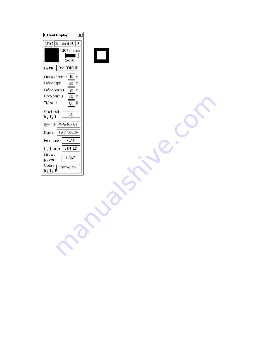
Chart page
Black and grey color symbol:
This symbol is used to verify that you can distinguish black (frame of symbol) and
grey (inner part of symbol) colors with current contrast and brilliance settings.
DISP Dimmer:
Use this control to adjust dimming of display. Text "CALIB"
indicates that dimming of display is set within calibration values.
Palette:
Choose appropriate palette for the display depending on the brightness of
the bridge.
Shallow contour:
Set value of shallow water contour. For more information, see the
section Setting value for Shallow Contour, Safety Depth, Safety Contour and Deep
Contour on the preceding page.
Safety depth:
Set value of safety depth. Spot soundings below the safety depth are
highlighted.
Safety contour:
Set value of safety contour. Visible safety contour is equal to set
value or if the contour of set value is not available then the visible safety contour is
next deeper contour than safety contour. For more information, see the section
Setting value for Shallow Contour, Safety Depth, Safety Contour and Deep Contour
on the preceding page.
Note:
The system uses safety contour also for chart alerts.
Deep contour:
Set deep water contour. For more information, see the section
Setting value for Shallow Contour, Safety Depth, Safety Contour and Deep Contour
on the preceding page.
TM reset:
In the true motion mode, own ship moves until it reaches the true motion reset borderline (set here), and
then it jumps back to an opposite position on screen based on its course. Set the limit for TM reset (in percentage).
Appears in ECDIS mode only.
Chart alert highlight:
Set chart alert highlight. For more information, see section 9.1.3 Highlighting chart alert
areas.
Symbols:
Select how to display chart symbols. The options are:
Simplified:
The shape of symbols is of modern design and the sea mark symbols are filled in a color.
Paper Chart:
The shape of symbols imitates traditional symbols used in paper charts.
Depths:
Set how to display different depth zones on the chart display. For more information, see the section Setting
value for Shallow Contour, Safety Depth, Safety Contour and Deep Contour on the preceding page.
For MULTI-COLOUR, the chart display uses four different colors for contours:
•
Deeper than user-chosen deep contour
•
Between deep contour and user-chosen safety contour
•
Between safety contour and user-chosen shallow water contour
•
Between shallow water contour and coastline.
For TWO-COLOUR, the chart display uses only two colors:
Deeper than safety contour
Shallower than safety contour
Boundaries:
Set how to display boundaries of some chart features. The options are:
Plain:
The line styles are limited to plain solid and dashed lines.
Symbolized:
Some of the line styles use symbols to highlight the purpose of a line.
Содержание FCR-2107 series
Страница 42: ...1 Operational Overview 1 20 This page intentionally left blank...
Страница 73: ...2 Radar Operation 2 31 ROUGH SEA SHIP HARBOR COAST Picture setup options and default settings con t...
Страница 154: ...5 AIS Operation 5 28 This page intentionally left blank...
Страница 253: ...7 Vector Chart Material 7 81 More information is available in text More information is available as a picture...
Страница 255: ...7 Vector Chart Material 7 83 Recommended track defined by two beacons...
Страница 256: ...7 Vector Chart Material 7 84 Recommended track defined by a building and a beacon...
Страница 257: ...7 Vector Chart Material 7 85 Measurement mile tails tails...
Страница 279: ...8 Manual Updates 8 19 12 10 11 9 13 7 8 Set positions with cursor and push left mouse button Click Accept button...
Страница 298: ...9 Chart Alerts 9 14 This page intentionally left blank...
Страница 322: ...10 Route Planning 10 24 This page intentionally left blank...
Страница 368: ...14 Backup Operations 14 6 This page intentionally left blank...
Страница 404: ...16 Recording Functions 16 16 This page intentionally left blank...
Страница 406: ...17 NAVTEX Messages 17 2 This page intentionally left blank...
Страница 416: ...19 Parameters Setup 19 8 This page intentionally left blank...
Страница 456: ...Appendix 2 IHO ECDIS Chart 1 AP 4 Information about the chart display 1 Information about the chart display 2...
Страница 457: ...Appendix 2 IHO ECDIS Chart 1 AP 5 Nature and Man made features Port features...
Страница 458: ...Appendix 2 IHO ECDIS Chart 1 AP 6 Depths Currents etc Seabed Obstructions Pipelines etc...
Страница 459: ...Appendix 2 IHO ECDIS Chart 1 AP 7 Traffic routes Special areas...
Страница 460: ...Appendix 2 IHO ECDIS Chart 1 AP 8 Aids and Services Buoys and Beacons...
Страница 461: ...Appendix 2 IHO ECDIS Chart 1 AP 9 Topmarks Color test diagram...
Страница 462: ...Appendix 2 IHO ECDIS Chart 1 AP 10 Mariners navigational symbols...
Страница 464: ...Appendix 3 Interpreting S57 Charts AP 12 Plain or symbolized boundaries Limited or full light sectors...
Страница 467: ...Appendix 3 Interpreting S57 Charts AP 15 Land features Water and seabed features Traffic routes...
Страница 468: ...Appendix 3 Interpreting S57 Charts AP 16 Cautionary areas Information areas Buoys and beacons Lights...
Страница 469: ...Appendix 3 Interpreting S57 Charts AP 17 Fog signals Radars Services...
Страница 472: ...Appendix 3 Interpreting S57 Charts AP 20 Low accuracy Services and small craft facilities Special areas...
Страница 474: ...Appendix 3 Interpreting S57 Charts AP 22 Light descriptions Nature of seabed Geographic names etc...
Страница 476: ...Appendix 3 Interpreting S57 Charts AP 24 This page intentionally left blank...
Страница 511: ...Appendix 5 Digital Interface AP 59 NRX NAVTEX received data...
Страница 544: ...Appendix 6 Parts List and Parts Location AP 92 This page intentionally left blank...
Страница 550: ...This page is intentionally left blank...
Страница 556: ......