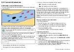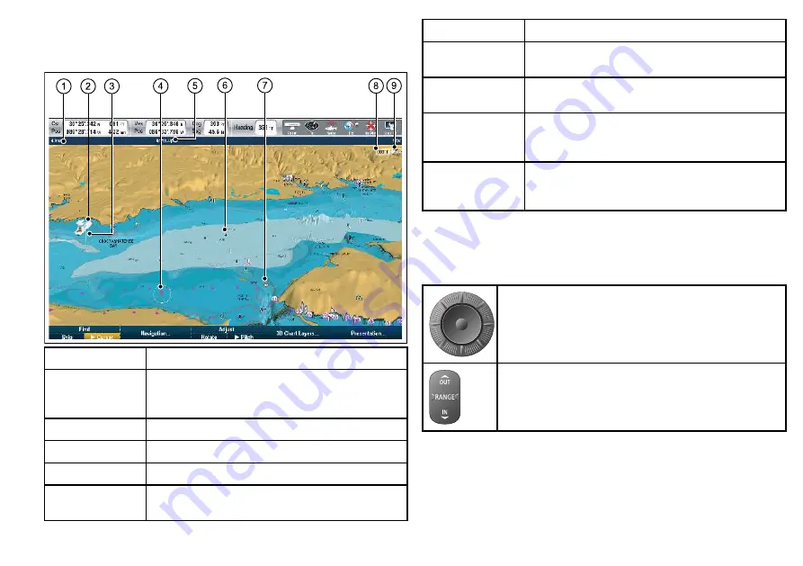
3D chart view
The 3D chart view includes a number of functions to help you
navigate your vessel.
Item
Description
1
Range
— horizontal distance across screen (halfway
up the window or at center of view). Shown in selected
system units.
2
Vessel symbol
— your vessel’s current position.
3
Depth Scale
— approximate depth beneath your vessel.
4
Waypoint
— with arrival circle.
5
Orientation
— states the orientation mode that the chart
is using.
Item
Description
6
Center-of-view
— the white cross indicates the center
of chart view at the water level.
7
Cartographic objects
— use the Cartography Setup
menu to choose which objects to display.
8
Rotation
— shows in degrees true, how far the
on-screen view has been rotated from your vessel’s
heading.
9
North arrow
– 3D indication of True North in relation
to the chart view. The north arrow also tilts to indicate
pitch angle.
Manipulating the chart view
Use a combination of the UniControl and range keys to manipulate
the chart view.
UniControl — is used for pitch, rotate and pan.
Range key— is used to zoom in and out.
1.
Chart pitch.
i. If the chart is in 3D mode, select the
Pitch
option from the
softkey toolbar
ii. Use the rotary control to change the pitch angle of the chart
display.
Using the chart
77
Summary of Contents for E-Series
Page 1: ......
Page 2: ......
Page 4: ......
Page 16: ...16 E Series Widescreen User reference...
Page 42: ...42 E Series Widescreen User reference...
Page 148: ...148 E Series Widescreen User reference...
Page 164: ...164 E Series Widescreen User reference...
Page 204: ...204 E Series Widescreen User reference...
Page 214: ...214 E Series Widescreen User reference...
Page 224: ...224 E Series Widescreen User reference...
Page 228: ...228 E Series Widescreen User reference...
Page 240: ...240 E Series Widescreen User reference...
Page 252: ...252 E Series Widescreen User reference...
Page 260: ......


