101
GPS
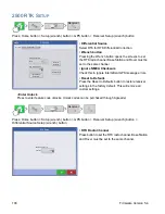
- ASAP represents a Hz value of more than 1.
• NMEA Messages
These checkboxes represent various communication protocols or formats that have been set by the
National Marine Electronics Association (NMEA), and used in information “strings” or sentences output by
the GPS Receiver. At present, the display only requires two NMEA Message formats: GGA and VTG.
- GGA: position in longitude and latitude.
- VTG: ground speed
- GSV, GSA: required to view the Satellite Plot, but are not required for GPS information.
- GLL, ZDA, RMC, MSS: Leave these other NMEA message formats unchecked, unless you are
connected to a third-party monitor and have been directed to do so.
GPS I
NFORMATION
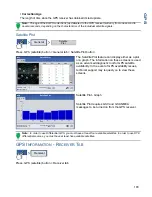
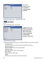
To access diagnostic information about the GPS signal, press the GPS (satellite) button
that appears in the in the upper left-hand side of the Status Bar. GPS Information then
appears on General, Receiver, and OmniSTAR tabs. Information on these GPS Information
screens is described on the following pages.
GPS I
NFORMATION
- G
ENERAL
T
AB
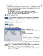
Press: GPS (satellite) button > General tab
• Latitude, Longitude, Elevation
Displays current position (in longitude and latitude) and
elevation.
• Heading
Displays degree heading of travel.
• Number of Satellites
• Differential
If a TSIP receiver is being used, the differential status
will display the differential source,(i.e. WAAS, Beacon or
OmniSTAR). This message field will display either Diff
On or No Diff.
- Diff On: Indicates the receiver is receiving a differential
GPS signal.
- No Diff: Indicates the receiver is not receiving a differential GPS signal.
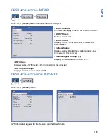
Otherwise, if RTK or NTRIP is being used, the differential status will display one of the following status
messages:
- RTK Fixed: The ParaDyme roof module is receiving a Valid RTK differential source.
- RTK Float: The ParaDyme roof module is receiving information from the Base Station, but the signal is
not strong enough for an RTK fix.
General
Satellite
Plot
View
Messages
General
Latitude (N)
Longitude (W)
Elevation (feet)
Heading:
Number of Satellites
Differential:
42.002632283
-93.628395273
948.730
183.92000
Diff On
UTC Time:
UTC Date:
GPS Information
GPS Speed (mph):
Position Rate:
14:08:18
03/08/2012
0 ‘ “
5 Hz
20:09:07
8
Speed/Heading Rate:
5 Hz
HDOP:
PDOP:
NMEA, 38400,8 N1
Port:
Frequency:
SNR:
Correction Age:
1.8
N/A
N/A
N/A
3.0
Summary of Contents for ag leader
Page 1: ...Operators Manual Firmware Version 5 4 Ag Leader PN 4002722 Rev G ...
Page 2: ...Firmware Version 5 4 ...
Page 20: ...6 Firmware Version 5 4 ...
Page 38: ...24 Firmware Version 5 4 For more information see Legend Settings on page 52 ...
Page 55: ...41 SETUP M ANAGEMENT S ETUP Remove button Press to remove a business ...
Page 56: ...42 Firmware Version 5 4 ...
Page 78: ...64 Firmware Version 5 4 ...
Page 82: ...68 Firmware Version 5 4 Press to Export All Log files Export All Log Files ...
Page 84: ...70 Firmware Version 5 4 ...
Page 94: ...80 Firmware Version 5 4 ...
Page 108: ...94 Firmware Version 5 4 ...
Page 140: ...126 Firmware Version 5 4 ...
Page 154: ...140 Firmware Version 5 4 ...
Page 158: ...144 Firmware Version 5 4 ...
Page 162: ...148 Firmware Version 5 4 ...
Page 222: ...208 Firmware Version 5 4 ...
Page 244: ...230 Firmware Version 5 4 ...
Page 260: ...246 Firmware Version 5 4 ...
Page 290: ...276 Firmware Version 5 4 ...
Page 304: ...290 Firmware Version 5 4 ...


