

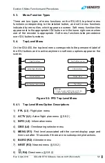


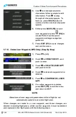


Section 5 Menu Functions and Procedures
5-12
IDU-450 EFIS Software Version 8.0H (Rotorcraft)
Rev A Apr 2019
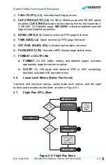
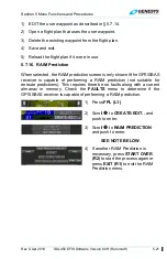
5.7.1. Flight Planner Page
The flight planner is used for following functions on pilot-modifiable
elements in the IDU database.
1) Manage stored flight plans (activate, create, edit, delete, and reverse);
2) Manage user waypoints (create, edit, and delete); and
3) Perform
RAIM
predictions.
Because the flight planner takes over the IDU’s controls, limitations are
placed upon access and display of the flight planner. The flight planner is
not available when a PFD page is being displayed on the IDU. (MFD in
reversion mode).
When the flight planner is accessed, it only appears on the MFD to preserve
access to crucial PFD page controls such as altimeter settings.
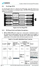
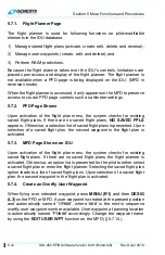
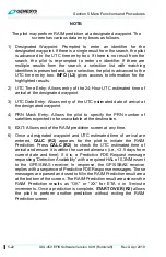
5.7.2. PFD Page Shown
Upon activation of the flight plan menu, the system checks for existing
saved flight plans. If there are no saved flight plans,
NO SAVED FPLS
appears. Otherwise, a selection list of saved flight plans is presented. Upon
selection of a saved flight plan, the second waypoint in the flight plan is
activated.
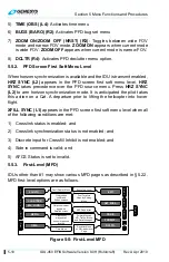
5.7.3. MFD Page Shown on IDU
Upon activation of the flight plan menu, the system checks for existing
saved flight plans. If there are no saved flight plans, the flight planner is
activated. Otherwise, an option list is presented for the pilot to either select
a saved flight plan or enter the flight planner. Selecting the saved flight plan
option leads to a list of saved flight plans. Upon selection of a saved flight
plan, the second waypoint in the flight plan is activated.
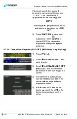
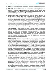
5.7.4. Create an Overfly User Waypoint
When flying over intended waypoint, press
MENU (R1)
and then
DESIG
(L3)
on the PFD or MFD. A user waypoint is created at the present position
and automatically named “OF###”, where ‘###’ is the next in sequence
overfly user waypoint number available. User waypoint at panning location
is automatically named “PN###” accordingly. Change the waypoint name
by using the
EDIT USER WPT
function on the MFD (§ 5.7.14).