


Section 3 Display Symbology
3-44
IDU-450 EFIS Software Version 8.0H (Rotorcraft)
1
st
Ed Nov 2018
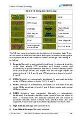
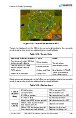
Table 3-15: Fuel Totalizer/Waypoint Distance Functions
Function Conditions
Type Symbols
Options
DEST
Waypoint
If there is an active flight plan, waypoint
type, identifier, range, and ETE/ETA for
the last waypoint (“DEST” waypoint) are
shown.
If the active waypoint is not the last
waypoint, range and time to destination
waypoint are based on the flight plan
route. Otherwise, range and time are
based on a direct geodetic path.
Waypoint information is white but turns
amber (yellow) with GPS LON caution.
ETA or ETE
Degree (°) or
True North (
T
)
symbol
Range
Based on instantaneous fuel flow, fuel remaining and
groundspeed are shown immediately below “DEST”
waypoint information for easy comparison.
Endurance Based on instantaneous fuel flow and fuel remaining is
shown.
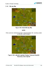
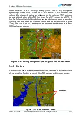
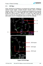
3.4.7. Navigation
Data
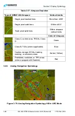
Figure 3-74: Navigation Data and Airspace Depiction
The ND displays navigation data in correct relationship to the ownship
symbol with navigation data symbols, which include airport symbols, NDBs,
and user waypoints. High altitude and low altitude airways may be shown.