


Section 3 Display Symbology
1
st
Ed Nov 2018
IDU-450 EFIS Software Version 8.0H (Rotorcraft)
3-67
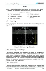
across the earth appears on the compass rose when groundspeed is
greater than or equal to 30 knots. A pilot-settable heading bug
geometrically interacting with the heading pointer appears on the compass
rose. A magenta, star-shaped waypoint pointer is displayed on the heading
scale at a point corresponding with the active waypoint, which turns amber
(yellow) in the event of GPS LON caution.
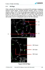
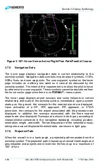
3.7.4. Active Flight Plan Path/Manual Course
Figure 3-106: Hover Vector Active Flight Plan Path/Manual Course
When there is an active flight plan and the GPS/SBAS OBS setting is
automatic, the flight plan path is shown on the hover page in its correct
relationship to the ownship symbol. The active flight plan path meets all the
requirements of GPS/SBAS path definition and matches the lateral
navigation guidance given on the PFD (GPS/SBAS CDI in automatic OBS
mode, skyway boxes, and mini map). Active flight plan path waypoints are
shown as fly-over or fly-by waypoints with the fly-over waypoint consisting
of a waypoint symbol within a circle. The fly-by waypoint consists of a
waypoint symbol without the circle.
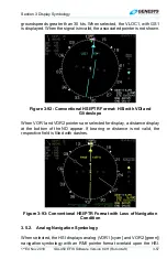
When there is a parallel offset, the active flight plan path depicts the parallel
offset path, and the original flight plan path is shown with haloed gray lines.
When there is an active waypoint and the GPS/SBAS OBS setting is
manual, the manual course through the waypoint is shown as a pointer
centered on the waypoint. The pointer matches the lateral navigation
guidance given on the PFD (GPS/SBAS CDI in manual OBS mode, skyway
boxes, and mini map).
The active flight plan path’s active leg/manual course and active waypoint
are magenta but turn amber (yellow) in the event of a GPS LON caution.