


Section 7 IFR Procedures
1
st
Ed Nov 2018
IDU-450 EFIS Software Version 8.0H (Rotorcraft)
7-1
Section 7
IFR Procedures
7.1.
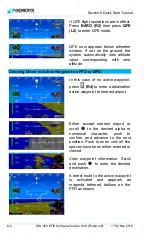
Active Flight Plan
Before using the Genesys EFIS GPS navigation system to fly any part of
an instrument procedure instrument procedure in VMC or IMC conditions,
always compare each leg of the applicable and current published charted
procedure to the flight plan displayed on the ND. This EFIS and FMS may
not support some specific navigation leg types. All pilots must understand
how each leg is depicted and navigated prior to conducting the procedure.
After updating the navigation database and planning to fly an instrument
procedure, practice in the RUN DEMONSTRATOR/TRAINING PROGRAM
to view how each leg is depicted in the aircraft EFIS limits
V
PROC
setting.
If navigation planning includes manual sequencing of any leg in a
procedure, verify what specific navigation guidance the EFIS provides.
When any procedure includes ARINC-424 legs defined by headings, or that
terminate at a specific altitude, the pilot must understand how the EFIS
behaves and how system behavior can affect coupled autopilot operations.
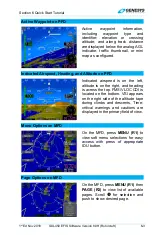
Upon activation of the active flight plan menu, the application checks for an
active waypoint. If there is no active waypoint,
appears.
Otherwise, a nav log of waypoints in the active flight plan appears with the
following:
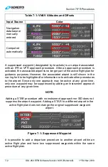
1) Waypoint identifier and characterization (default, overfly [
OF
], or no
radius [
0R
])
2) Symbol designating waypoint type and what type of procedure (if any)
the waypoint is associated
3) VNAV altitudes and offsets associated with each waypoint
4) Information related to flight plan path between each waypoint
In the case of an approach with a final approach segment data block, the
VNAV offset readout associated with the missed approach point is “GPI” to
designate distance to the glidepath intercept point. When courses are
presented as part of the path information, they are displayed referenced to
either magnetic or true north depending upon the status of the true north
discrete input. If referenced to magnetic north, the course is indicated with
the degree (°) symbol. Otherwise, a stylized true north (
T
)
symbol appears.
The active waypoint is designated by an asterisk and is magenta but turns
amber (yellow) in the event of a GPS LON caution.