


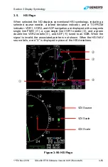

Section 3 Display Symbology
1
st
Ed Nov 2018
IDU-450 EFIS Software Version 8.0H (Rotorcraft)
3-43
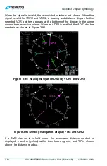
b) Speed in knots;
c) Crosswind component in knots; and
d) Graphical wind vector arrow oriented to correspond to the ND
orientation.
NOTE:
Wind information is not shown when the aircraft is in the ground mode, or
when the AHRS is in DG mode. If referenced to magnetic north, direction
readout uses the degree (°) symbol. Otherwise, a stylized true north (
T
)
symbol is used.
2)
Outside Air Temperature:
Digitally in degrees C or F (as configured).
3)
International Standard Atmosphere (ISA)
: Difference between ISA
temperature and current outside air temperature is displayed digitally
in °C or °F (negative values = less than standard OAT). Decluttered if
the “Show ISA Temperature Flag” is disabled in EFIS limits.
4)
Density Altitude:
Digitally in feet. Decluttered if “Show Density altitude
Flag” is disabled in EFIS limits.
5)
True Airspeed:
Digitally in knots. Decluttered if “True Airspeed Flag”
is disabled in EFIS limits.
6)
Groundspeed:
Digitally in knots.
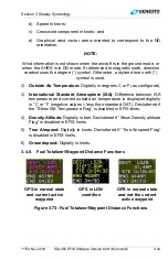
3.4.6. Fuel Totalizer/Waypoint Distance Functions
GPS in normal state
and current active
waypoint
GPS in LON
condition
GPS in normal state
and not the current
active waypoint
Figure 3-73: Fuel Totalizer/Waypoint Distance Functions