


Section 8 Terrain Awareness Warning System
8-6
IDU-450 EFIS Software Version 8.0H (Rotorcraft)
1
st
Ed Nov 2018
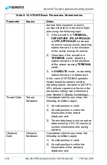
c)
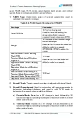
Approach Mode
: Based on a 10
change in track followed by 30
seconds of flight at aircraft groundspeed. Maximum width is 0.3NM
either side of track.
d)
Departure Mode
: Based on a 10
change in track followed by 30
seconds of flight at aircraft groundspeed. Maximum width is 0.3NM
either side of track.
After calculating search volume width as described above, the GPS/SBAS
HFOM is added to search volume width.
1)
Aircraft Bank Angle
: Used to expand the search volume in the
direction of a turn and requires at least 10
of bank. In addition, search
volume expansion is delayed so at 10
of bank, the bank angle must
be continuously held for 3.25 seconds, which is reduced linearly with
increased bank angle so at 30
of bank there is no delay time.
2)
Aircraft Vertical Speed
: If above 500 fpm, vertical speed is used to
determine which RTC values should be used. At vertical speeds less
than 500 fpm, level and climbing flight RTC values apply. A three-
second pilot reaction time is used and applied to the level-off rule
parameters.
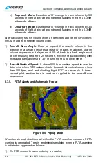
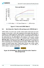
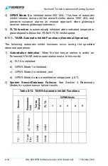
8.3.5. FLTA Alerts and Automatic Popup
Figure 8-5: Popup Mode
When terrain or obstructions fall within the FLTA search envelope, a FLTA
warning is generated. Terrain rendering is enabled when a FLTA warning
is initiated or upgraded as follows:
1) On PFD screen, terrain rendering is enabled;