


Section 8 Terrain Awareness Warning System
8-20
IDU-450 EFIS Software Version 8.0H (Rotorcraft)
1
st
Ed Nov 2018
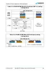
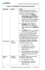
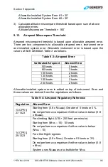
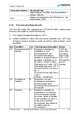
Table 8-13: TAWS Automatic Inhibit Functions
Sen
sor
Para
me
ters
Los
t
Te
rra
in
D
is
p
lace
d
FLTA
GPWS Mode
1 2 3 4 5
GPS/S
BAS (V) +
ADC
+ RADL
T
M
S
L A
lti
tud
e,
VSI, AG
L
AL
T
Inhibit
Inhibit
Inhibit
Inhibit
Inhibit
Inhibit
Inhibit
Notes:
1) Combinations listed give the minimum combinations with the worst
consequences. Many other combinations are possible, but their effects
are subsumed within the combinations listed.
2) GPS/SBAS (H) = HFOM > max (0.3NM, HAL). Indication is loss of
terrain display on PFD and ND.
3) GPS/SBAS (V) = VFOM > 106’.
4) GPS/SBAS = GPS/SBAS (H) + GPS/SBAS (V). Indication is loss of
terrain display on PFD and ND.
5) TD = Terrain Data invalid. This would be due to being beyond the
database boundaries or database corruption.
6) ADC = Air Data Computer. Indication is
flag, or red Xs indicating a
single ADC failure.
7) RADALT = Radar Altimeter. Indication is lack of
radar altimeter source indication on radar altimeter
display.
8) ILS = ILS Glideslope Deviation. Indication is lack of glideslope needles.
9) MSL = MSL Altitude Invalid. Indication is
or
in the absence of other failures.