


Section 8 Terrain Awareness Warning System
8-16
IDU-450 EFIS Software Version 8.0H (Rotorcraft)
1
st
Ed Nov 2018
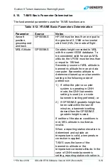
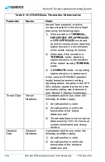
Table 8-12: HTAWS Basic Parameters Determination
Parameter Source
Notes
derived from waypoint or active
runway elevations in the active flight
plan using the following logic:
1) If the aircraft is in
TERMINAL,
DEPARTURE
,
IFR APPROACH
,
or
VFR APPROACH
mode and
an active runway exists, reporting
station elevation is the elevation
of the active runway threshold.
2) Otherwise, if the aircraft is in
TERMINAL
mode, reporting
station elevation is the elevation
of the airport causing
TERMINAL
mode.
3) In
ENROUTE
mode, no reporting
station elevation is determined.
In the case of GPS/SBAS geodetic
height-based barometric setting,
reporting station elevation is the GPS
MSL altitude reported at the time the
barometric setting was determined
(see Section 3 Display Symbology).
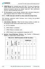
Terrain Data
Terrain
Database
Considered valid for use, when the
following conditions apply:
1) Aircraft position is valid;
2) Aircraft position is within the
boundaries of the terrain
database; and
3) Terrain database is not corrupt as
determined by CRC-32 checks at
system initialization and during
runtime.
Obstacle
Data
Obstacle
Database
Considered valid for use, when the
following conditions apply:
1) Aircraft position is valid;
2) Aircraft position is within the
boundaries of the obstacle
database; and