1. OPERATION
1-56
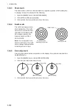
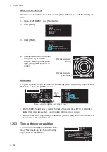
3. Click [BARGE DELETE].
4. Click [COLOR].
5. Click the barge color to delete.
6. Click outside the menu window to close the menu.
How to delete all barge marks
1. Do the procedure from step 1 to step 3 in "How to delete barge marks by color" on
2. Click [BARGE ALL DELETE].
3. Click [YES].
4. Click outside the menu window to close the menu.
1.35
NAV Data
The following navigation data may be set up on the menu.
1.35.1
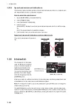
How to show ship’s position or speed and depth alternately
At the top right corner on the screen, click the icon below to switch between “Speed
and Depth” and “Own ship position”.
Speed menu
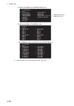
Right-click the speed icon ([SPD]) to show [SPEED MENU].
- Speed
- Depth
- Own ship position
- Time to the cursor position - Wind
- Date
- ROT graph
- Rudder graph
- AUTOPILOT graph
1 BACK
2 COLOR
GRN/BLU/YEL/CYA/
MAG/WHT
3
BARGE ALL DELETE
NO/YES
[BARGE
DELETE]
“speed” and “depth”
“latitude and longitude”
(own ship position)
Click
CAPT
±300 °/min
±180 °
SPD BT GPS-F
►
DPT AFT
►
CURSOR TTG
18m20s
01-sep-2012
►
44. 6km/h
3. 2m
UTC
12:34
6.34NM / 300.3°R
CAPT
±300 °/min
±180 °
OS POSN N
CURSOR TTG
18m20s
2. 4m/s
0° 00. 219°
WIND
E
0° 00. 397°
►
6.34NM / 300.3°R
Right-
click
1 BACK
2
SELECT DUAL SENSOR
FRONT/AFT
3 SHIP
SPEED
SOG/STW
4
GROUND SPEED SOURCE
GPS/REF/LOG(BT)
5
WATER SPEED SOURCE
LOG(WT)/MANUAL
6 MANUAL
SPEED
0. 0kn
7 SET
DRIFT
OFF/ON
8
SET CURRENT CRS
0. 0deg
9
SET CURRENT SPD
0.
0kn
CAPT
±300 °/min
±180 °
DPT AFT
►
CURSOR TTG
18m20s
01-sep-2012
►
44. 6km/h
3. 2m
SPD BT GPS-F
►
SPD BT GPS-F
►
6.34NM / 300.3°R
UTC
12:34
Speed icon
[SPEED
MENU]


