


SV-MAP-270 Navigation Mapping Software
SkyView Classic Pilot’s User Guide –
Revision Z
7-75
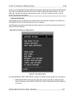
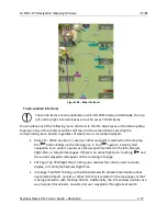
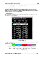
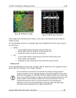
Map Info Items
•
MAIN MENU > MAP > MAP MENU> INFO ITEMS: Use these settings to display up to
10 informational items along the left and right sides of the Map Page. Items
available for display include:
o
Bearing to Waypoint.
o
Cross Track:
▪
This is the shortest possible distance that can possibly be traveled that will
put you back on course. Essentially, it is the perpendicular distance from the
current location to the course line.
o
Current Location
o
Destination Waypoint:
▪
Identifier of the final waypoint in your flight plan.
o
Distance to Go:
▪
The total distance remaining along the flight plan.
o
Distance to Waypoint:
▪
Distance to the currently active waypoint.
o
ETA (Final):
▪
The estimated time of arrival at the final waypoint in the flight plan. This time
does not account for time zone changes. If GPS ground speed is <25 knots,
the Plan Ground Speed setting (MAP MENU > MAP MENU > FLIGHT PLAN
OPTIONS) is used so that you can see approximate travel times while on the
ground.
o
ETA (Next):
▪
The estimated time of arrival at the next waypoint in the flight plan. This time
does not account for time zone changes. If GPS ground speed is <25 knots,
the Plan Ground Speed setting (MAP MENU > MAP MENU > FLIGHT PLAN
OPTIONS) is used so that you can see approximate travel times while on the
ground.
o
ETE (Final):
▪
The remaining estimated time enroute to the final waypoint in the flight
plan. If GPS ground speed is <25 knots, the Plan Ground Speed setting (MAP
MENU > MAP MENU > FLIGHT PLAN OPTIONS) is used so that you can see
approximate travel times while on the ground. Display switches from hh:mm
to mm:ss automatically.
o
ETE (Next):


