
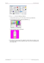


Adding and Using User Bitmap Charts
MicronNav System
0656-SOM-00001-07
95
© Tritech International Ltd.
Shortened Marker File Format (.csv extension)
This file format is a more concise and usable format, particularly for loading a pre-defined
target list into Seanet Pro. The file is in an ASCII Comma Separated format and contains
the following fields:
Index
Value
Description
1
ID
This is a unique string ID. It comprises a 2 letter header ("mk") followed
by a DateTime code. Any unique string value is acceptable.
3
X Coordinate
For the .csv file, will be in coordinate system used in Seanet (either
Longitude or UTM Easting).
4
Y Coordinate
For the .csv file, will be in coordinate system used in Seanet (either
Latitude or UTM Northing).
17
Comment
Comment text.
11
Shape Type
0 = Circle, 1 = Square, 2 = Triangle, 3 = Sonar Range, 4 = Preset
Image (see Image Info below).
16
Image Info
Presets = Red Flag, Blue Flag, Green Flag, Buoy, Anchor, Rock,
Danger, POI, ViewPort, Sonar, Diver, Wheel, Comment or MLO
Alternatively can be full path and name of an image file (e.g. 'C:
\Image1.bmp').
10
Date & Time
Date & Time in English(GB) Locale.
Format is "dd/mm/yyyy hh:mm:ss"
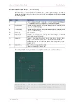
For example, the following two markers would produce a two line .csv file as shown:
mk41149.5595988657,-2.1991799999203,56.9600300036883,Possible Wreck Site,4,Red Flag,
28/08/2012 13:25:51
mk41149.5605201736,-2.19877999992026,56.9598200036882,WARNING! ROCKS,4,Rock,
28/08/2012 13:27:48


