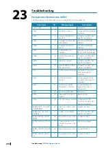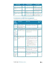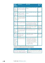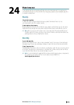
SCAMIN
The minimum scale at which the object may be used
SOG
Speed over ground
SPD
Speed
SPD/CRS
Speed/Course
STBD
Starboard side
STW
Speed through the water
TCS
Track control system
TTG
Time to go
UTM
Universal transverse Mercator
UTC
Universal time, coordinated
VDR
Voyage data recorder
VRM
Variable range Mercator
WGS
World geodesic system
Wind T/R
Wind True or Relative
WOP
Wheel over point
WPT
Waypoint
Chart management and charts
AIO
Admiralty Information Overlay
ARCS
Admiralty Raster Chart Service
AVCS
Admiralty Vector Chart Service
ENC
Electronic Navigational Charts
GB
AVCS chart collection
PM
Primar chart collection
RCDS
Raster chart display system
S-57 (IHO S-57)
Electronic navigational chart standard format
SENC
ECDIS chart format
SA certificate
Scheme Administrator certificate
Annexes
| ECDIS900 Operator Manual
199

