


The remapping feature is important since you may not have control over the range or
resolution of the non-IRIS data. Products from non-IRIS systems can be reformatted to
match the standard IRIS formats and then inserted into IRIS using the Input pipes
mechanism.
Vaisala supplies source code examples to customers who want to reformat non-IRIS data
and insert it into IRIS. These products can then be sent to the composite IRIS workstation
either directly, from an external user program, or through another IRIS.
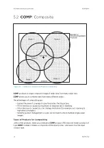
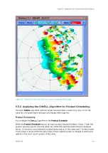
Composites of Composites (Regional, National/International Composites)
The maximum number of radars that can be used in a composite is 16. This is adequate for
most applications.
For larger networks, it is recommended to first make regional composites, and then
composite the composites to make national or international composites.
5.2.1 Composite Algorithm
Basic Rules
COMP
takes products from several radar sites and combines them into a single product
using the following rules:
• The input products must be of the same type (for example,
CAPPI
) and have the same
name.
This is the recommended way to manage products on your network in general.
Note that IRIS sorts everything by site for you, so there is no need to put a site ID in the
name.
The product type and name are specified in the
COMP Product Configuration Menu
.
• The products must be within a certain time window to be combined.
You would not want to combine data if the input products were more than a few
minutes apart.
The time window is specified in the
COMP Product Configuration Menu
.
Remapping
The products to be composited are remapped to the common projection that is specified in
the
COMP Product Configuration Menu
.
Ideally,
PPI
s and
CAPPI
s should be at the same elevation angles and heights.
If they are not at the same elevation angles and heights, there are tolerances for combining
PPI
products of slightly different elevations (for example, 1°) and
CAPPI
products of
different heights (1000 m (3280 ft 10 in)).
Combining
For regions where radars overlap, you can select one of the following methods for
combining radar data:
•
Maximum
Maximum uses the maximum value to combine the data. This is the most common
setting.
IRIS Product and Display User Guide
M211319EN-H
130
RESTRICTED
Содержание IRIS
Страница 1: ...M211319EN H RESTRICTED User Guide IRIS Radar IRIS Product and Display...
Страница 12: ...IRIS Product and Display User Guide M211319EN H 10 RESTRICTED...
Страница 71: ...Chapter 3 Configuring IRIS Products RESTRICTED 69...
Страница 294: ...To add icons you must include a text next to the icon IRIS Product and Display User Guide M211319EN H 292 RESTRICTED...
Страница 303: ...Figure 103 Typical Spectrum Plot Appendix A Basic Radar Meteorology RESTRICTED 301...
Страница 324: ...Figure 109 Example of Volume Rendering IRIS Product and Display User Guide M211319EN H 322 RESTRICTED...
Страница 329: ...C 8 Using the Product Information Tool Figure 113 Product Information Tool Appendix C IRIS 3DView RESTRICTED 327...
Страница 386: ......
Страница 392: ......
Страница 393: ......
Страница 394: ...www vaisala com...