


10. Choosing Overlay Files
10.1 Overlay Overview
This utility is a legacy feature used when viewing radar data with IRIS Analysis.
When possible, Vaisala recommends viewing radar data with IRIS Focus.
You can use the IRIS
Overlay
utility to draw overlays or maps for display on top of other
IRIS/Open products. Overlays are used for product output and the real-time display.
An overlay can consist of the following:
• Geographical and political boundaries displayed with or without latitude and longitude
lines or range rings.
• Text strings to label areas of interest, such as cities.
• Bitmap Icons that can be constructed by the user and applied to the overlay. Icons can
represent any feature, for example, airports, train stations, and similar.
• The lines, text and icons mentioned above can be separated into different layers within
the overlay file. Then at display time, either all or only a subset of these layers may be
displayed giving yielding overlays that appear different based on which layers are
active. Layers can be drawn in different colors.
• Underlays are filled regions of color displayed under the radar images where there is no
weather data. Underlays are typically used to indicate areas of water.
Each overlay is defined in an ASCII file using a connect-the-dots approach (sometimes
called a vector approach). This allows overlays to be drawn to any scale factor.
You use the
Overlay
utility to create and modify your own overlays in a window on your
workstation.
Typically, you get the basic map (coastlines, borders, rivers) from Vaisala and then
customize it to meet your needs. It is often convenient to make separate layers for different
interests (river catchments, airports). IRIS supports up to 20 overlay files.
IRIS overlays are ASCII files so you can edit them with any text editor (
vi
, or
emacs
which is
distributed with IRIS).
10.2 Invoking Overlay
1. Invoke the
Overlay
utility by typing:
overlay&
Overlay starts as a default with an empty window on your workstation.
Settings from your previous session are still valid when you restart.
Chapter 10 – Choosing Overlay Files
RESTRICTED
287
Содержание IRIS
Страница 1: ...M211319EN H RESTRICTED User Guide IRIS Radar IRIS Product and Display...
Страница 12: ...IRIS Product and Display User Guide M211319EN H 10 RESTRICTED...
Страница 71: ...Chapter 3 Configuring IRIS Products RESTRICTED 69...
Страница 294: ...To add icons you must include a text next to the icon IRIS Product and Display User Guide M211319EN H 292 RESTRICTED...
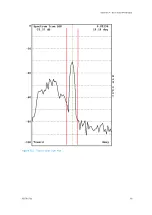
Страница 303: ...Figure 103 Typical Spectrum Plot Appendix A Basic Radar Meteorology RESTRICTED 301...
Страница 324: ...Figure 109 Example of Volume Rendering IRIS Product and Display User Guide M211319EN H 322 RESTRICTED...
Страница 329: ...C 8 Using the Product Information Tool Figure 113 Product Information Tool Appendix C IRIS 3DView RESTRICTED 327...
Страница 386: ......
Страница 392: ......
Страница 393: ......
Страница 394: ...www vaisala com...


