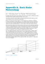


Appendix C. IRIS 3DView
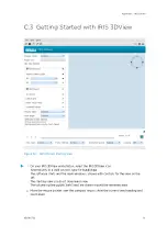
C.1 IRIS 3DView Overview
IRIS 3DView software is a separately licensed software package that renders 3D
visualizations of IRIS format radar data.
The radar data can be rendered using surface or volume rendering over a detailed 3D terrain
map of the land and water underneath the weather echoes. The 3D visualization can also be
rendered over a 2D radar product.
IRIS 3DView allows the rendered scene to be rotated, panned, and zoomed. You can add
additional detail layers such as radar range rings, latitude-longitude grid, and landmark
labels to the view for easy navigation.You can also store preferred view angles and display
states for later use.
You can view the data files (Archive Mode) or configure IRIS 3DView to monitor a data file
directory for viewing of the latest radar data (Live Mode). The input radar data may be data
collected from a single weather radar, or from an IRIS composite of multiple radars.
You can export bitmap images of the 3D visualization, and run a background process that
automatically renders bitmap images of the incoming radar data.
IRIS Product and Display User Guide
M211319EN-H
310
RESTRICTED
Содержание IRIS
Страница 1: ...M211319EN H RESTRICTED User Guide IRIS Radar IRIS Product and Display...
Страница 12: ...IRIS Product and Display User Guide M211319EN H 10 RESTRICTED...
Страница 71: ...Chapter 3 Configuring IRIS Products RESTRICTED 69...
Страница 294: ...To add icons you must include a text next to the icon IRIS Product and Display User Guide M211319EN H 292 RESTRICTED...
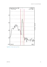
Страница 303: ...Figure 103 Typical Spectrum Plot Appendix A Basic Radar Meteorology RESTRICTED 301...
Страница 324: ...Figure 109 Example of Volume Rendering IRIS Product and Display User Guide M211319EN H 322 RESTRICTED...
Страница 329: ...C 8 Using the Product Information Tool Figure 113 Product Information Tool Appendix C IRIS 3DView RESTRICTED 327...
Страница 386: ......
Страница 392: ......
Страница 393: ......
Страница 394: ...www vaisala com...