


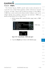


11-41
190-01004-03 Rev. P
GTN 625/635/650 Pilot’s Guide
Weather
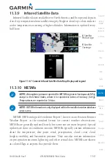
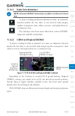
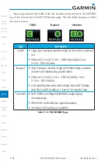
11.3.9 Infrared Satellite Data
Infrared Satellite data is available over North America and Europe and depicts
cloud top temperatures from satellite imagery. Brighter cloud top colors indicate
cooler temperatures occurring at higher altitudes. Information is updated every
half hour.
IR Satellite
Coverage
IR Satellite
Product Age
Figure 11-67 Connext Infrared Satellite Data Map Display and Legend
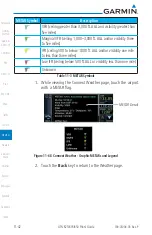
11.3.10 METARs
NOTE:
Atmospheric pressure reported for METARs is given in hectopascals (hPa),
except in the United States, where it is reported in inches of mercury (in Hg).
Temperatures are reported in Celsius.
NOTE:
METAR information is only displayed within the installed aviation database
service area.
METAR (METeorological Aerodrome Report), known as an Aviation Routine
Weather Report, is the standard format for current weather observations.
METARs are generally updated hourly, but some site are more frequent. Special
updates are done as conditions warrant. METARs typically contain information
about the temperature, dew point, wind, precipitation, cloud cover, cloud
heights, visibility, and barometric pressure. They can also contain information
on precipitation amounts, lightning, and other critical data. METARs are shown
as colored flags at airports that provide them.
Содержание GTN 625
Страница 608: ...This page intentionally left blank ...
Страница 609: ......
Страница 610: ...190 01004 03 Rev P ...


