


8-25
190-01004-03 Rev. P
GTN 625/635/650 Pilot’s Guide
Map
Airspace Labels
The Airspace Label feature shows the United States airspace system altitude
limits up to a selected range.
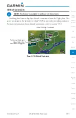
NOTE
: This feature is available in software v5.10 and later when configured
by the installer.
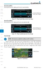
Airspace Labels - On
Airspace Labels - On
Figure 8-28 Display of Airspace Labels
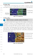
Smart Airspaces
Garmin’s Smart Airspace™ feature aids visual clarity on-screen by de-
emphasizing airspace that’s well above or below the aircraft’s current altitude.
The vertical separation is 1,000 feet at sea level and the vertical separation will
gradually increase to 2,000 feet until the aircraft reaches 10,000 feet. Anything
above 10,000 feet keeps the 2,000 feet vertical separation.
NOTE:
Smart Airspace only changes the depiction of the airspace on the
moving map display. It does not alter the Airspace Alerts that can be set
on the System-Alerts portion of the system.
Smart Airspaces - On
Smart Airspaces - Off
Figure 8-29 Display of Smart Airspaces (Airspace Borders Grayed)
Содержание GTN 625
Страница 608: ...This page intentionally left blank ...
Страница 609: ......
Страница 610: ...190 01004 03 Rev P ...


