11-46
GTN 625/635/650 Pilot’s Guide
190-01004-03 Rev. P
Weather
11.4
FIS-B Weather
NOTE: FIS-B information is to be used for pilot planning decisions and pilot near-
term decisions focused on avoiding areas of inclement weather that are beyond
visual range or where poor visibility precludes visual acquisition of inclement
weather. FIS-B weather and NAS status information may be used as follows:
(a) To promote pilot awareness of own ship location with respect to
reported weather, including hazardous meteorological conditions,
NAS status indicators, and enhance pilot planning decisions and pilot
near-term
decision-making.
(b) To cue the pilot to communicate with the Air Traffic Control controller,
Flight Service Station specialist, operator dispatch, or airline operations
control center for general and mission critical meteorological information,
NAS status conditions, or both.
FIS-B information, including, weather information, NOTAMs, and TFR areas,
are intended for the sole purpose of assisting in long- and near-term planning
decision making. The system lacks sufficient resolution and updating
capability necessary for aerial maneuvering associated with immediate
decisions.
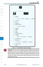
The Flight Information Services (FIS-B) function is capable of displaying text
and graphic weather information with GDL 88 and GTX 345 installations. No
subscription for FIS-B services is required.
The FIS-B Function is a graphic weather display capable of displaying
graphical weather information on UAT equipped installations. Graphical data is
overlaid on the map indicating the rainfall detected by ground based radar for a
specific area. The colors indicating increasing levels of rainfall progresses from
light green for light rainfall to magenta for heavy rainfall. Review the Limitations
section in the front of this guide for the limitations that apply to the FIS-B data.
Содержание GTN 625
Страница 608: ...This page intentionally left blank ...
Страница 609: ......
Страница 610: ...190 01004 03 Rev P ...


