Glossary
MLGPS-P
User's Guide
93
Differential GPS
(
DGPS
) ‒ A method of using multiple GNSS receivers, with at least one as a reference with
known coordinates, to eliminate shared parameters that cause errors. For example, a
Rover
station is the
GNSS receiver attached to the structure being monitored. Its exact coordinates are not known; they are being
calculated. It
is
known that there will be some degree of error in these calculated coordinates, predominately
due to atmospheric conditions, but it is not known how much error is present. This error can be more or less
determined by using a reference station, known as a
Base Station
. The Base Station has known coordinates,
but it will also calculate coordinates for itself like the Rover does. These known coordinates can be compared
to the calculated coordinates, and the difference between the known coordinates and the calculated
coordinates is the error. It can now be assumed that the Rover is experiencing a similar error, which can be
accounted for by offsetting the Rover's calculated coordinates with the error calculated by the Base Station.
The resulting coordinates should be more accurate to the true coordinates of the Rover. If set up correctly,
Differential GPS can greatly reduce or nearly eliminate atmospheric related errors and other sources of noise,
and can result in sub-centimeter accuracy.
This relies on the assumption that the Base Station and Rover are experiencing the same or very similar
atmospheric conditions. In order to increase the likelihood that they see the same conditions, the
baseline
should be as short as possible.
Differencing can be doubled or tripled up to further increase accuracy ‒ this is known as
double
and
triple
differencing
. This ensures that, through the use of additional baselines, change in position of Base Stations is
noticed and accounted for. Without multiple baselines, this change would be assumed to be an atmospheric
error and would be factored into the Rover's readings, causing additional error.
Dilution of Precision
(
DOP
) ‒ The geometric strength of a satellite constellation. This is determined by the
number of satellites visible, the elevation and azimuth of the satellites, clock offset and the existence of any
obstructions of the sky view of the receiver. In GNSS positioning, the stronger the constellation, meaning the
smaller the DOP, the higher the accuracy. Therefore, the more satellites the receiver has line-of-site with, the
better three-dimensional positioning will be, with a minimum of four required for any positioning to be possible.
DOP can appear in the following forms:
▪
Geometric DOP
(
GDOP
) ‒ Uncertainty of latitude, longitude, height and clock offset.
▪
Position DOP
(
PDOP
) ‒ Uncertainty of latitude, longitude and height.
▪
Horizontal DOP
(
HDOP
) ‒ Uncertainty of latitude and longitude.
▪
Vertical DOP
(
VDOP
) ‒ Uncertainty of height.
▪
Time DOP
(
TDOP
) ‒ Uncertainty of clock offset.
Doppler
‒ Doppler is the difference in Hertz of the frequency received versus calculated, caused by satellite
and receiver movements. The processing engine will provide corrections to the data based on the Doppler
effects.
Electrical Phase Center
‒ The
electrical phase center
is the point where the satellite signal is collected in a
GNSS antenna. This will differ amongst makes, models and styles of antennas. This can be accounted for and
offset via MultiLogger
. The electrical phase center is not a stable point, and due to antenna phase center
variation, will change depending on the broadcast direction of the signal being received.
Elevation
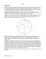
‒ The vertical angle in degrees between the satellite and the receiver's local horizon. The figure
below shows a satellite with an Elevation of 15
above the horizon from the receiver's location. Generally, the
closer to the horizon, the weaker the signal and the more likely that the line-of-sight is obstructed by objects.


