Glossary
94
MLGPS-P
User's Guide
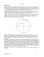
Elevation Mask
‒ Because satellites with low Elevations can have low signal to noise ratios and more
multipath errors, Elevation Mask allows for the "masking" of satellites below a set Elevation. This means that
the satellites with an Elevation below the Elevation Mask setting will not be used in positioning. The default is
5
.
Ephemeris
‒ Ephemeris data is broadcast every 30 seconds by each satellite within the constellation, and
provides very precise orbital and clock corrections for the satellite that is broadcasting it. It also contains
information about the position of the satellite in space, with respect to time. Also called
broadcast ephemeris
.
Extended Kalman Filter
(
EKF
) ‒ The nonlinear version of the Kalman filter, which is a recursive algorithm that
estimates current state variables using a series of measurements observed over time. The processing engine
deploys the EKF to obtain final solutions.
Frequency Lock Loop
‒ GNSS receivers have code and carrier tracking loops that are used to continuously
follow the code and carrier parameters of the carrier signals. The
Frequency Lock Loop
is within the tracking
loops, and tracks and estimates error of the frequency, so that a correction can be provided to eliminate that
error. Tracking the frequency and correcting the error is an integral part of the carrier phase measurement. See
Carrier Phase Measurement for more information.
Gateway IP Address
‒ The router's LAN IP address.
GLONASS
‒ A Russian GNSS that became fully operable in 2002. The MLGPS
is capable of tracking
GLONASS satellites.
GNSS
‒ Global Navigation Satellite System. This is a constellation of Earth-orbit satellites large enough to
provide continuous global coverage of navigation and positioning data to GNSS receivers on the ground or in
vehicles, allowing those receivers to determine their precise location in three-dimensions in real-time.
GNSS/GPS Monitoring
‒ The use of GNSS's, or specifically GPS, to provide 3D positioning data for GNSS
receivers affixed to a monitored structure. Deformation can be monitored over time by tracking movement in
the position of the receivers. GNSS/GPS monitoring has advantages over more traditional forms of deformation
monitoring in terms of cost, precision, range and automation capabilities.
GPS
‒ The NAVSTAR-
G
lobal
P
ositioning
S
ystem. GPS is an American GNSS. It was the first attempt at a
GNSS, launched in 1977, and became operable in 1993. Full operation was achieved in 1995. It consists of up
to 32 satellites, with at least 24 in operation at all times, assuring that the majority of receivers will have line-of-
site with at least four satellites at any given time.
Health
‒ Satellites can experience many malfunctions, errors, and corrections. Information on these issues and
the overall quality of the signals is referred to as the satellite's
health
. Satellites broadcast information on their
health with the NAV message, so that GNSS receivers know not to use unhealthy satellites for positioning.
Innovation
‒ In the Kalman filter, innovation is defined as the difference between the observation
(measurement) and what was predicted at a given time. Innovation helps to describe how well an estimator is
performing. The estimator will, with what information it has, make a prediction of what the next measurement
will be. The measurement will be made, the innovation will show the difference between the estimated
measurement and the true measurement, and the estimator will correct given the new information. The
processing engine allows the innovation to be used in solution settings, in that it can be used to set the outlier
threshold for the pseudorange and carrier phase measurements. If an innovation value is too high, the
observable will be considered an outlier and will not be used in processing.
Insolation
‒ The amount of solar radiation on the surface of the earth at a given time. Insolation is variable
region to region. Also called
solar insolation
.

