


Section 1 - Introduction
MLGPS-P
User's Guide
11
1.3 Theory of Operation
Global Navigation Satellite System
(GNSS) monitoring is increasingly being used in geotechnical and structural
applications for high accuracy positioning. It provides continuous, near real-time 3D information that can be
accurate within millimeters. It is typically used for deformation monitoring of engineered structures such as
dams, bridges, retaining walls, etc., as well as natural structures such as hillsides and rock faces.
The first GNSS ‒ the
Global Positioning System
(GPS) ‒ was originally developed by the US Department of
Defense and became fully operational in 1995. Since then, several other GNSS's have begun development,
with Russia's GLONASS becoming the second GNSS to become fully operational, and the European Galileo
and Chinese BeiDou-3 (BDS) scheduled for completion in 2020. GNSS receivers on the ground can determine
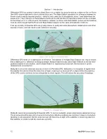
their location and local time by receiving time signals from satellites. A line-of-sight is required between the
satellite and the receiver, so a sufficient constellation of satellites, in number and location within orbit, is
needed for continuous and reliable coverage ‒ this is referred to as
dilution of precision
, or DOP.
Communication between receivers and satellites is done through microwave signals within the L band (1 - 2
GHz) range of the radio spectrum. The L1 carrier frequency and the C/A (course acquisition) code that is
broadcast with it are the two signals being used for our applications.
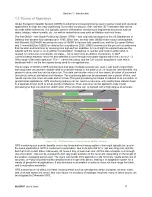
The principle of GNSS or GPS monitoring is that when multiple receivers are used, static positioning at high
sampling rates can provide valuable data on potential change in the position of the receivers, and therefore, the
ground or structures they are located upon. This data can include velocity of movement, direction of movement
(horizontal, vertical, elevation) and vibration. The positioning data can be processed over a period of time, and
results can become more accurate and error free. This post processing technique is referred to as a
solution
. In
geotechnical applications, GPS monitoring stations can be fixed to a structure, with nearby base stations fixed
to a separate known point to act as points of reference. Then, solutions can be applied to data in post
processing so that movement or deformation of the structure can be tracked with a high degree of accuracy.
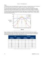
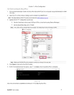
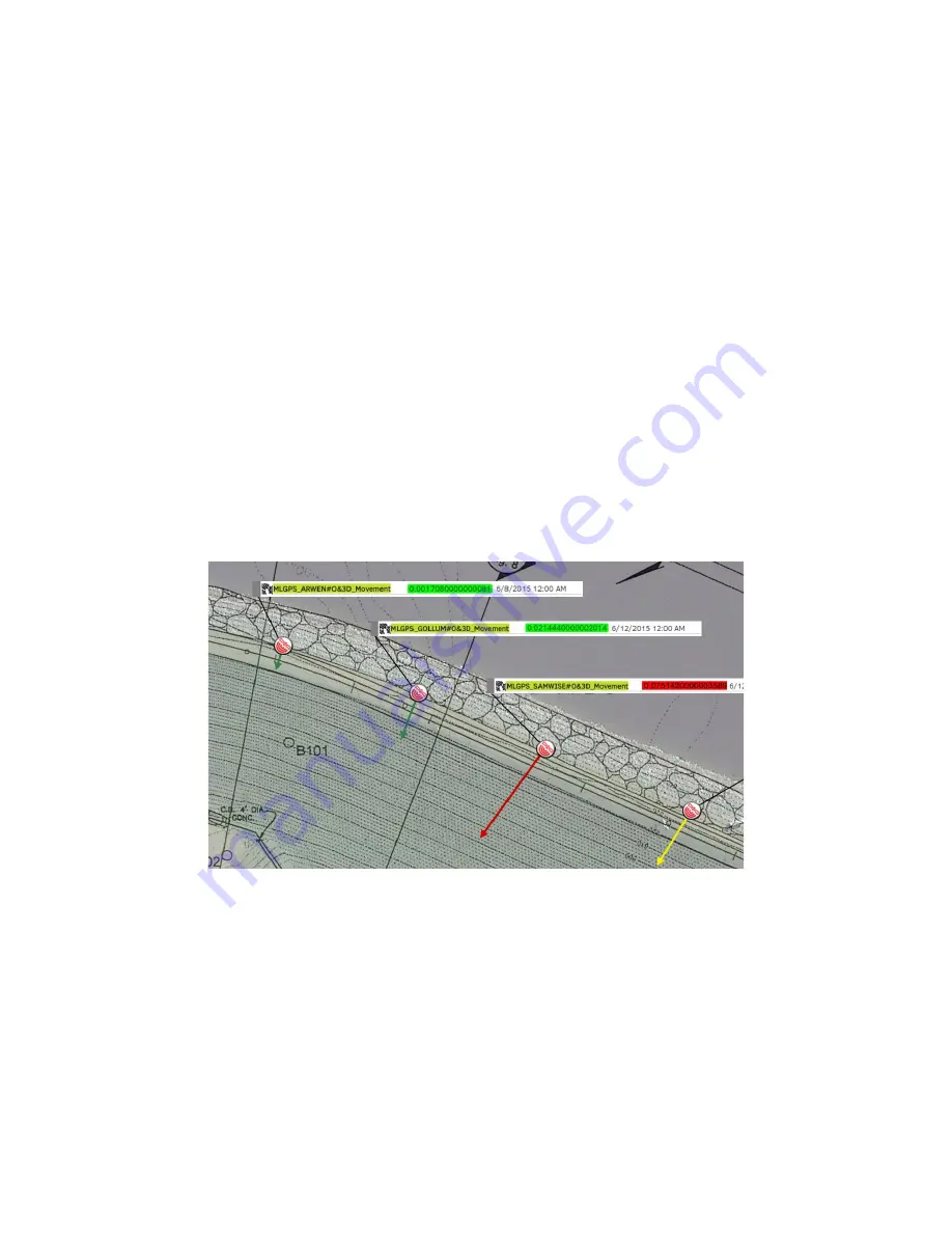
(Figure 1.3 A ‒ GPS Monitoring in Canary Systems' MLWeb
software)
GPS monitoring can provide benefits over many terrestrial monitoring systems that might typically be used in
the same applications. GPS is conducive to automation, due to its potential for a high sampling rate, and the
fact that it can collect data continuously, 24 hours a day, in near real-time. GPS is also accurate, and through
use of solutions, data can be averaged to find very exact positions of the receivers, depending on the length of
the position averaging period used. The users can decide if the application calls for timely results at the cost of
accuracy, or highly accurate results compiled over a longer time period, making it an adaptable system for a
variety of geotechnical applications. It also functions in all weather conditions, does not have range limitation,
and is accessible worldwide.
GPS monitoring is not without its flaws. Issues persist, such as atmospheric delay, multipath, receiver noise,
and clock and ephemeris errors, that can reduce the accuracy of readings. However, many of these issues can
be mitigated by
Differential GPS
.