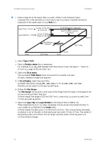
1. Construct a series of
CAPPI
products to span the selectable layer, spaced uniformly
over the height interval. The number used is the larger of one for every 500 meters
(1640 ft 5 in) or one for every 2 pixels of side panel size, up to a maximum of 50. The
values are interpolated to create the side panel image.
2. Determine the maximum data values for the horizontal and vertical projections: East-
West and North-South.
• The horizontal maximum projection is calculated from the highest data value in a
user-specified layer over each pixel.
• The E-W maximum projection is obtained from the maximum data for each pixel
along the corresponding N-S line.
• The N-S maximum projection is obtained from the maximum data along E-W lines.
3. Smoothing, if enabled.
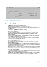
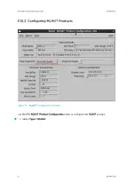
3.9.1 Configuring MAX Products
Figure 11
MAX
Example Configuration
Chapter 3 – Configuring IRIS Products
RESTRICTED
45
Summary of Contents for IRIS
Page 1: ...M211319EN H RESTRICTED User Guide IRIS Radar IRIS Product and Display...
Page 12: ...IRIS Product and Display User Guide M211319EN H 10 RESTRICTED...
Page 71: ...Chapter 3 Configuring IRIS Products RESTRICTED 69...
Page 303: ...Figure 103 Typical Spectrum Plot Appendix A Basic Radar Meteorology RESTRICTED 301...
Page 386: ......
Page 392: ......
Page 393: ......
Page 394: ...www vaisala com...


