

iSXblue/SXBlue II GNSS Series Technical Reference Manual
63
•
If any of these memory coordinates are within 10 meters of the current fix, the closest
one will be used automatically as reference point and the iSXBlue/SXBlue will start
computing differential corrections.
•
If there are no coordinates saved in memory or if the differences between the current
position and the memory coordinates are greater than 10 meters then the receiver will
automatically average a 300 second position and use it as Reference Point to compute the
differential corrections.
b)
Manual mode. If $JMODE,FIXLOC is set to YES, the iSXBlue/SXBlue II will not go into an
automatic average process but instead, will use the last Reference Point or a new user-entered set
of coordinates (with $JRTK,1,lat,lon,height) or wait for a user-forced average of the antenna
location (using $JRTK,1,R).
In all cases, the $JRTK,1 command returns the coordinates of the Reference memory location (reference
point being used by the iSXBlue/SXBlue II) and will be equal to the content of either the Manual or the
Automatic memory location.
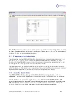
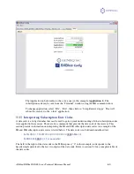
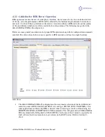
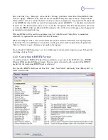
4.2.1.2
Base Station Configuration
The use of SXBlue Config is recommended for easy setup of the iSXBlue/SXBlue II as a base station (see
following sub-section). This section lists the normal steps involved in this process (please refer to Chapter
5 for details on the commands mentioned here):
•
Set the antenna in a perfectly clear view of the sky. Make sure the base station is at least 50
meters (160 feet) away from obstructions. If using a radio modem, the transmitting antenna
should be at least 3 meters away from the iSXBlue/SXBlue II antenna. Do not set the antenna
directly on the ground but at least 75cm above all surface.
•
Set the receiver to base mode with the following command $JMODE,BASE,YES and set the
satellite elevation mask to 5 or 10 degrees with $JMASK,5 (or ,10).
•
If the coordinates will be entered manually or if the last memory saved is to be used, then issue
the $JMODE,FIXLOC,YES (default) command. This will prevent the receiver from going into
automatic averaging.
•
Enter the reference coordinates of the antenna location using the $JRTK,1,lat,lon,height
($JRTK,1 alone replies with the set of coordinates being used) or wait for the automatic
averaging to be completed. Note that the coordinates must be entered in degrees decimal and the
height should be expressed in meters. Also note that the antenna height above ground along with
the antenna phase center offset (see section 1.4) should be taken into account (for example if
occupying a survey monument, add the pole height plus the phase center offset to the benchmark
height).
•
If broadcasting corrections to a rover of a different brand, make sure it supports SBAS ranging in
the RTK ambiguity resolution, otherwise turn off SBAS parameters in the differential correction
messages using the $JMODE,SBASNORTK,YES command.
•
You may also select the GNSS signals to be output in the differential correction messages. By
default, correctors for both GPS and GLONASS are activated with the following commands:
$JDIFFX,GNSSOUT,GPS,YES and $JDIFFX,GNSSOUT,GLONASS,YES. If one of the two
types is to be omitted replaced the last argument with a “NO”.


