


iSXblue/SXBlue II GNSS Series Technical Reference Manual
107
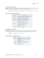
This command has the following layout:
$JRAD,1,lat,lon,alt<CR><LF>
Where the data fields in this command are described in the following table.
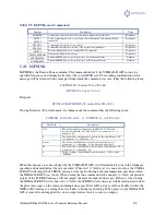
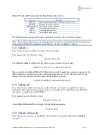
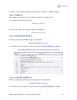
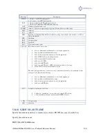
Data Field
Description
lat
This is the latitude of the reference point in degrees decimal degrees.
lon
This is the longitude of the reference point in degrees decimal degrees.
alt
This is the ellipsoidal height of the reference point in m. (Ellipsoidal height can
be calculated by adding the altitude and geoidal separation, both available from
the GGA sentence. See example below.)
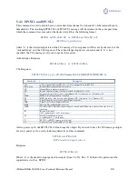
Example of ellipsoidal height calculation:
$GPGGA,173309.00,5101.04028,N,11402.38289,W,2,07,1.4,1071.0,M,-17.8,M,6.0, 0122*48
ellipsoidal height = 1071.0 + (-17.8) = 1053.2 meters
The iSXBlue/SXBlue II GNSS will reply with the following response:
$>JRAD,lat,lon,alt
Note - Both latitude and longitude must be entered as decimal degrees. The receiver will not accept
the command if there are no decimal places.
5.7.4
$JRAD,2
This command is used to force the receiver to use the new reference point. This command is normally
used following a $JRAD,1 type command.
This command has the following format:
$JRAD,2<CR><LF>
The iSXBlue/SXBlue II GNSS will reply with the following response:
$>JRAD,2,OK
5.7.5
$JRAD,3
This command is used for two primary purposes. The first is to invoke the Auto-Dif function once the
unit has started up (with the Auto-Dif application active). The second purpose is to update the Auto-Dif
solution using the current position as opposed to the reference position used by the $JRAD,2 command.
This command has the following format:
$JRAD,3<CR><LF>
The receiver will respond with the following command if it has tracked enough satellites for a long
enough period before you sent the command. This period of time can be from 3 to 10 minutes long and is
used for modeling errors going forward.
$>JRAD,3,OK<CR><LF>