iSXblue/SXBlue II GNSS Series Technical Reference Manual
157
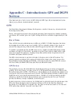
GPS Signal Multipath
Satellite signals received by the GPS receiver by a reflection from an object can decrease positioning
accuracy. These multipath signals increase the measured range to a satellite as the signal takes a longer
route to the GPS antenna. Certain precautions will minimize GPS antenna sensitivity to these reflected
signals. Operating away from large reflective structures such as buildings or using special antennas and
GPS equipment can help to reduce the impact of multipath. For most consumer-level applications, a
small amount of multipath is tolerable.
GPS Receiver Quality
The quality of a GPS receiver has a dramatic influence on positioning accuracy. Consumer-based GPS
products, such as many affordable handheld and fixed-mount receivers, typically operate with an
accuracy of 3 to 5 meters horizontally 95% of the time. The accuracy of a particular product depends on
the specific receiver’s performance characteristics. Higher accuracy GPS receivers are able to achieve
sub-1 meter horizontal accuracy 95% of the time using real-time DGPS transmissions. The
iSXBlue/SXBlue II GNSS falls into this latter category.
Space Based Augmentation Systems (SBAS)
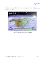
The US Federal Aviation Administration has developed a Wide Area Augmentation System (WAAS) for
the purpose of providing accurate positioning to the aviation industry. In addition to providing a high
quality and accurate service for this industry, this service is available free of charge to all other civilian
users and markets in Central and North America. This service falls into the greater category of Space
Based Augmentation System (SBAS).
Upon the successful completion of a 21-day test on August 24, 2000, the Federal Aviation Administration
of the United States of America announced that its Wide Area Augmentation System (
WAAS
) would be
running 24 hours per day, seven days per week from then on. Testing has shown since that this signal is
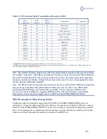
accurate and reliable. Since the date it was commissioned (July 10, 2003), WAAS has undergone a few
changes in its satellite constellation and coverage (PRN 122 and 134 phased out and replaced by PRN 135
and 138 at new locations; and with the addition of ground monitoring stations in Canada and Mexico in
September 2007). In summer 2010, PRN 133 has been added to the constellation and in late December
2010, PRN 135 was recovered after being out of control for a few months, bringing the total number of
operational satellites to three.
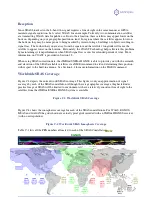
Other government agencies have followed the pace and developed compatible SBAS systems for their
respective geographic regions. In Europe, the European Space Agency, the European Commission, and
EUROCONTROL have jointly developed the European Geostationary Overlay System (
EGNOS
).
EGNOS is now fully deployed and in its pre-operational phase. The system will undergo certification for
safety-of-life applications before becoming fully operational. Furthermore, on June 28, 2007, the
European Space Agency and the Agency for Security of Air Navigation in Africa and Madagascar have
signed a cooperation agreement with the objective of using satellite navigation to improve air traffic
safety over the African continent.
In Japan, the MTSAT Satellite-based Augmentation System (
MSAS
) has been deployed by the Japan
Civil Aviation Bureau (JCAB). Successful launches of MTSAT-1R and MTSAT-2 were followed by
system integration for MSAS ground system and MTSATs by transmitting test signal from MTSATs.
Purposes of test signal transmission were to optimize system performance and then to verify that


