© 2021 Copyright Newmar Corporation. All rights reserved. For the most up-to-date version of this content, and for more product-specific information, please refer to Newgle.
112
ELECTRONICS
Some buttons, fields, or icons may not be available in
your product version.
NOTICE
!
Changing some of these settings may not have an
e
ff
ect in your current region if the map data do not
contain the required information.
NOTICE
!
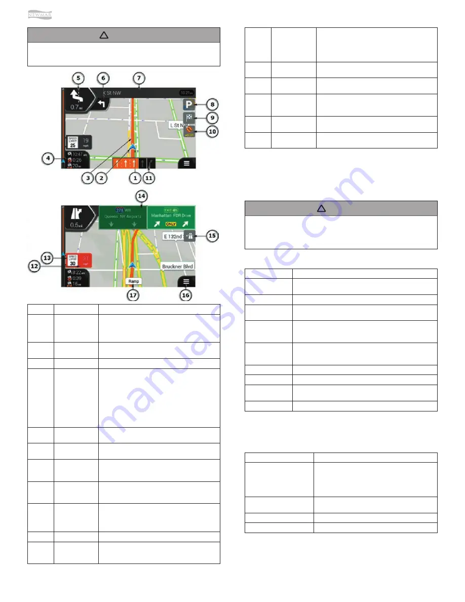
Number
Name
Description
1
Current Position
Marker
The current position is displayed as a blue arrow by
default. When there is no GPS position, the current
position marker is transparent and it shows your last
known position.
2
GPS Position
The dot near the arrow shows the GPS position as
perceived by the GPS receiver.
3
Planned Route
The planned route is displayed as an orange line.
4
Data Fields
Three data fields show the following information:
•
The estimated time of the arrival at the
destination.
•
The remaining time of the trip.
•
The remaining distance to the destination.
You can change the default values in Settings or by
tapping and holding the area where the data fields
appear. If you have not selected a destination, you
can see your heading instead of the three data fields.
5
Next Turn
Preview
It shows the type of the next maneuver and its
distance.
6
Second Next Turn
Preview
It shows the type of the second next maneuver if it is
near the first one.
7
Next Street
It displays the name of the next street. If you have
not selected a route destination, you can see nearby
house numbers, if they are available.
8
Parking Around
Destination
It appears near the destination. By tapping it, you
can check the available parking facilities around your
destination.
9
Destination Menu
It appears near the destination. By tapping it, you can
check the trip summary, find Places around your final
destination, save the current location, or suspend the
navigation.
10
Tra
ffi
c
It shows tra
ffi
c-related information.
11
Lane Information
On multi-lane roads, it shows the lanes ahead and
their directions. The highlighted arrows represent the
lanes and direction you need to take.
BUTTON
FUNCTION
Route Preferences
Select the type of vehicle you are driving, the road types used in
route planning, and the route planning method.
Sound
Adjust the di
ff
erent sound volumes.
Warnings
Enable and set up warnings for speed limit, Alert Points (such as
speed cameras).
Navigation View
Fine-tune the appearance of the Navigation view or adjust how
the program helps you navigate with di
ff
erent kinds of route-
related information on the Navigation view.
Regional
Change the voice guidance language, set the time zone, the
measurement units, the time and date formats, and customize
the application for your local language.
Display
Enable or disable menu animations.
Tra
ffi
c
Enable or disable tra
ffi
c information and modify detour settings.
Weather
Enable the online weather forecast and the automatic download
of weather information.
Online Services
Enable or disable services that require Internet connection.
BUTTON
FUNCTION
Vehicle
Set the type of vehicle you want to use to navigate
the route. Based on this setting, some of the road
types can be excluded from the route, or some of the
restrictions may not be taken into account in route
calculation.
Route Planning Method
Optimize the route calculation for di
ff
erent situations
and vehicle types by changing the planning method.
Navigation Mode (On-Road)
Select on-road or o
ff
-road navigation.
Road Types
Select your preferred road types for the route.
12
Alert Point
Warning
It shows the type of the alert points when
approaching a road safety camera or other Alert
Points like school zones or railroad crossings. You
must make sure that using this feature is legal in the
country where you intend to use it.
13
Speed Limit
Warning
It shows the current speed and the speed limit when
speeding.
14
Signpost
It shows the available destinations and the road
numbers.
15
Freeway Services
By tapping it, you can check the details of the next
few service stations (gas stations, restaurants) when
traveling on a freeway.
16
Navigation Menu
By tapping it, you can open the Navigation menu,
where you can reach other parts of the program.
17
Street Name
It shows the current street name. By tapping it, you
can open the Where Am I screen.
Settings Menu
You can configure the navigation settings, and modify the
behavior of the program, by tapping the MENU button (3
horizontal lines), followed by the SETTINGS button.
ROUTE PREFERENCES SETTINGS
The following settings determine how routes are
calculated:
The Settings menu provides the following options:
Содержание VENTANA 2022
Страница 1: ...SM 2022...


