Section 3: Operation
NetClock/GTP Instruction Manual
Page 3-21
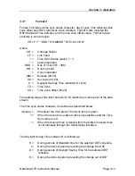
3.3.6 Format
90
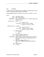
Format 90 provides a position data stream in NMEA 0183 GPGGA GPS Fix data
format. The Format 90 data structure is shown below:
$GPGGA,HHMMSS.SS,ddmm.mmmm,n,dddmm.mmmm,e,Q,SS,YY.y,+AAAAA.a,M,,,,*CC CR LF
where:
$GP = GPS System Talker
GGA = GPS Fix Data Message
HHMMSS.SS = Latest time of Position Fix, UTC. This field is blank until a
3D fix is acquired
ddmm.mmmm,n = Latitude
dd = degress, 00...90
mm.mmmm = minutes, 00.0000....59.9999
n = direction, N = North, S = South
dddmm.mmmm,e = Longitude
ddd = degress, 000...180
mm.mmmm = minutes, 00.0000....59.9999
e = direction, E = East, W = West
Q = Quality Indicator,
0 = No 3D fix
1 = 3D fix
SS = Number of satellites tracked, 0...8
YY.Y = Dilution of precision, 00.0...99.9
+AAAAA.a,M = Antenna height in meters, referenced to mean sea level
,,,, = Fields for geoidal separation and differential GPS not
supported
cc = Check sum message, HEX 00...7F
Check sum calculated by Xoring all bytes between $
and *.
CR = Carriage Return
LF = Line Feed

